IMAGES TAKEN NEAR TO
Hurst Road, STOKE-ON-TRENT, ST8 7RU
Introduction
This page details the photographs taken nearby to Hurst Road, ST8 7RU by members of the Geograph project.
The Geograph project started in 2005 with the aim of publishing, organising and preserving representative images for every square kilometre of Great Britain, Ireland and the Isle of Man.

There are currently over 7.5m images from over14,400 individuals and you can help contribute to the project by visiting https://www.geograph.org.uk
Image Map
Images are licensed for reuse under creativecommons.org/licenses/by-sa/2.0
Notes
- Clicking on the map will re-center to the selected point.
- The higher the marker number, the further away the image location is from the centre of the postcode.
Image Listing (90 Images Found)
Images are licensed for reuse under creativecommons.org/licenses/by-sa/2.0
Image
Details
Distance
1
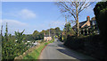
Hurst Road
Looking north along Hurst Road- a fairly narrow, but very scenic, road that runs from Grange Road to Biddulph Moor. This stretch in particular has some fantastic views across the valley.
Image: © Jonathan Kington
Taken: 13 Oct 2010
0.03 miles
2
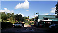
Old Quarry
This quarry looks to have been a stone quarry that has fallen into disuse. The buildings on the right, next to what looks like a former weighbridge, are occupied by a precision engineering company called J2K Engineering Ltd ( http://www.j2kengineering.co.uk/index.html ).
Image: © Jonathan Kington
Taken: 6 Oct 2010
0.07 miles
3
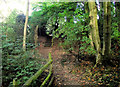
Steps to Hurst Road
Taken from close to where Image was taken, these steps lead to the Hurst Road entrance to Biddulph Grange Country Park and emerge opposite to the entrance of the former quarry (Image).
Image: © Jonathan Kington
Taken: 6 Oct 2010
0.07 miles
4
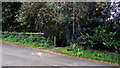
Entrance to the country park
Located on Hurst Road, opposite the entrance to the Image, is this almost hidden entrance to Biddulph Grange Country Park. From here you descend the steps shown in Image
Image: © Jonathan Kington
Taken: 6 Oct 2010
0.07 miles
5
Exiting the country park
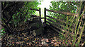
Close to where the steps lead up to Hurst Road (Image) a public footpath leaves Biddulph Grange Country Park via this stile and leads to Grange Road, approximately 600 metres away.
Image: © Jonathan Kington
Taken: 13 Oct 2010
0.11 miles
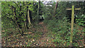
6
Footpath to Grange Road
Close to where the Image lead out of Biddulph Grange Country Park there is a public footpath that leads to Grange Road, approximately 600 metres away. Hidden amongst the bushes ahead is the stile that can be seen in Image
Image: © Jonathan Kington
Taken: 13 Oct 2010
0.11 miles
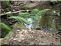
7
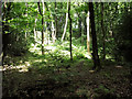
Sun in the woods
The sun is shining through a gap in the canopy giving light to the undergrowth.
Image: © Jonathan Kington
Taken: 2 Jun 2011
0.12 miles
8
Looking back to the old bridge
Looking down the hill towards the old bridge (Image and Image) just visible at the bottom. The bridge was built in the mid 1850's for James Bateman as part of an extended walk through what was then part of the Biddulph Grange estate, the area is now Biddulph Grange Country Park. The bridge is Grade II listed and details can be found here http://www.britishlistedbuildings.co.uk/en-488207-bridge-biddulph .
Image: © Jonathan Kington
Taken: 6 Oct 2010
0.12 miles
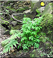
9
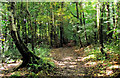
Fern by the stream
This Broad Buckler-fern is growing beside the Himalayan Walk on Biddulph Grange Country Park.
Image: © Jonathan Kington
Taken: 2 Jun 2011
0.13 miles
10
Welsh Poppy
Meconopsis cambrica growing between the Himalayan Walk and the stream on Biddulph Grange Country Park. For a close-up of the flower see Image
Image: © Jonathan Kington
Taken: 2 Jun 2011
0.13 miles