IMAGES TAKEN NEAR TO
Hot Lane, STOKE-ON-TRENT, ST8 7HP
Introduction
This page details the photographs taken nearby to Hot Lane, ST8 7HP by members of the Geograph project.
The Geograph project started in 2005 with the aim of publishing, organising and preserving representative images for every square kilometre of Great Britain, Ireland and the Isle of Man.

There are currently over 7.5m images from over14,400 individuals and you can help contribute to the project by visiting https://www.geograph.org.uk
Image Map
Images are licensed for reuse under creativecommons.org/licenses/by-sa/2.0
Notes
- Clicking on the map will re-center to the selected point.
- The higher the marker number, the further away the image location is from the centre of the postcode.
Image Listing (6 Images Found)
Images are licensed for reuse under creativecommons.org/licenses/by-sa/2.0
Image
Details
Distance
1
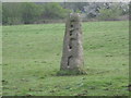
Post and rail Gatepost
This type of gatepost, where the rails were slotted into the stone post, was once a common method used instead of going to the expense of having a gate that needed replacing every few years. Originally there would have been a pair.
Image: © Jonathan Kington
Taken: 23 Apr 2009
0.12 miles
3
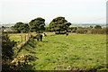
Biddulph Moor
Cattle grazing near Broomhouse Farm on Biddulph Moor
Image: © Richard Croft
Taken: 6 Sep 2012
0.22 miles
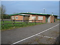
6
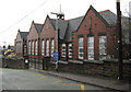
Biddulph Moor First School
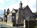
This very imposing, brick built, school was built in 1909 as a new Council-run school. Possibly it replaced the former church run school that is now the Church Hall (Image), but that is only supposition on my part.
Image: © Jonathan Kington
Taken: 5 Jan 2011
0.24 miles