IMAGES TAKEN NEAR TO
Davos Drive, STOKE-ON-TRENT, ST8 7FF
Introduction
This page details the photographs taken nearby to Davos Drive, ST8 7FF by members of the Geograph project.
The Geograph project started in 2005 with the aim of publishing, organising and preserving representative images for every square kilometre of Great Britain, Ireland and the Isle of Man.

There are currently over 7.5m images from over14,400 individuals and you can help contribute to the project by visiting https://www.geograph.org.uk
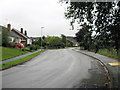
Image Map
Images are licensed for reuse under creativecommons.org/licenses/by-sa/2.0
Notes
- Clicking on the map will re-center to the selected point.
- The higher the marker number, the further away the image location is from the centre of the postcode.
Image Listing (85 Images Found)
Images are licensed for reuse under creativecommons.org/licenses/by-sa/2.0
Image
Details
Distance
1
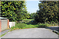
Looking through the gate
This is the gate from Pennine Way to the private fields belonging to Selectus that surround the Uplands Mill (Image), plans have been approved for a two hundred house development to be built here.
Image: © Jonathan Kington
Taken: 21 Sep 2010
0.00 miles
2
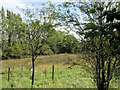
Selectus land behind Uplands Mill
Viewed from the rear entrance to Uplands Mill (Image and Image) on Pennine Way. Plans have been approved for a new housing estate of up to two hundred dwellings here.
Image: © Jonathan Kington
Taken: 21 Sep 2010
0.04 miles
3
Down Carriage Drive
Looking down the straight section after the Image
Image: © Jonathan Kington
Taken: 29 Aug 2010
0.06 miles
4
Up Carriage Drive
Image: © Jonathan Kington
Taken: 29 Aug 2010
0.07 miles
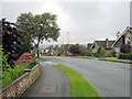
5
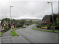
Looking up Carriage Drive
Looking towards the junction with Crossways.
Image: © Jonathan Kington
Taken: 29 Aug 2010
0.07 miles
6
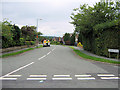
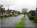
Carriage Drive
Taken from its junction with Pennine Way, Carriage Drive will eventually become Greenway Road and emerge in Woodhouse Lane (Image).
Image: © Jonathan Kington
Taken: 9 Aug 2010
0.07 miles
7
Bends on Carriage Drive
A bit further down from where Image was taken.
Image: © Jonathan Kington
Taken: 29 Aug 2010
0.07 miles
8
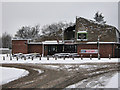
The Roaring Meg
This pub, located on the junction of Thames Drive and Pennine Way, is reputedly named after one of Oliver Cromwell's big cannons. For another view in different weather conditions see Image, and for a picture of the sign see Image
Image: © Jonathan Kington
Taken: 5 Jan 2010
0.08 miles
9
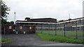
Uplands Mill (2)
Once the only company licensed to produce Velcro in Britain the ribbon makers, Selectus Ltd, have now outsourced all their work to the Far East and it looks like this factory might well be redundant; especially as there is now planning permission for a new housing estate here.
Image: © Jonathan Kington
Taken: 29 Aug 2010
0.08 miles
10
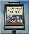
Sign for the Roaring Meg
This is the sign for the Roaring Meg on Pennine Way (for a view of the pub see Image and Image). It is interesting that the picture is of a wheeled cannon because the pub is supposed to have been named after Cromwell's Parliamentarian forces guns which were, in fact, mortars that had no wheels (see Image by Pauline Eccles). But the Cavalier regiment under the command of the Earl of Northampton did have a wheeled cannon that was also called the Roaring Meg, plus there was also a Roaring Meg cannon used in the Siege of Derry in 1689 (see Image by Eric Jones). See the Wikipedia article at http://en.wikipedia.org/wiki/Roaring_Meg_%28cannon%29 .
Image: © Jonathan Kington
Taken: 11 Sep 2010
0.09 miles