IMAGES TAKEN NEAR TO
Smithy Lane, STOKE-ON-TRENT, ST8 7EW
Introduction
This page details the photographs taken nearby to Smithy Lane, ST8 7EW by members of the Geograph project.
The Geograph project started in 2005 with the aim of publishing, organising and preserving representative images for every square kilometre of Great Britain, Ireland and the Isle of Man.

There are currently over 7.5m images from over14,400 individuals and you can help contribute to the project by visiting https://www.geograph.org.uk
Image Map
Images are licensed for reuse under creativecommons.org/licenses/by-sa/2.0
Notes
- Clicking on the map will re-center to the selected point.
- The higher the marker number, the further away the image location is from the centre of the postcode.
Image Listing (105 Images Found)
Images are licensed for reuse under creativecommons.org/licenses/by-sa/2.0
Image
Details
Distance
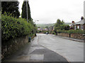
1
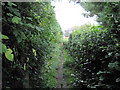
Looking towards Smithy Lane
Looking along the short public footpath between Congleton Road and Smithy Lane. Running between private back gardens, this path is very narrow and enclosed. This view is towards Smithy Lane and where this picture was taken: Image
Image: © Jonathan Kington
Taken: 8 Sep 2010
0.02 miles
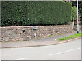
2

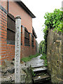
Public footpath from Congleton Road
This is the Congleton Road end of the short public footpath that goes to Smithy Lane (Image), because it passes a lot of private gardens this path is very narrow and enclosed. There is a benchmark cut into the stone wall on the right, see Image
Image: © Jonathan Kington
Taken: 8 Sep 2010
0.03 miles
3
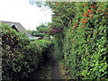
Public footpath from Smithy Lane
This footpath, only marked on the 1:25000 map, runs from Smithy Lane to Congleton Road. There is a benchmark cut into one of the stones on the right near the top of the steps, see Image
Image: © Jonathan Kington
Taken: 29 Aug 2010
0.04 miles
4
Footpath towards Congleton Road
This short public footpath runs from Smithy Lane to Congleton Road, and is only marked on the 1:25000 maps. As can be seen it is very enclosed because it runs between back gardens, this picture has been taken just along from where Image was taken.
Image: © Jonathan Kington
Taken: 8 Sep 2010
0.05 miles
5
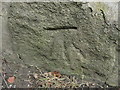
Benchmark by Smithy Lane
This benchmark is cut into a stone in the wall by the start of the Image Normally the Ordnance Survey would be able to use this cut mark to determine an elevation, but this one has been disturbed and now has a definite lean to the left that makes it unusable.
Image: © Jonathan Kington
Taken: 8 Sep 2010
0.05 miles
6
Along Smithy Lane
Looking along Smithy Lane from its junction with Woodhouse Lane.
Image: © Jonathan Kington
Taken: 29 Aug 2010
0.06 miles
7
Sign for The Uplands
This is the sign at the junction of Smithy Lane and Image
Image: © Jonathan Kington
Taken: 9 Aug 2010
0.06 miles
8
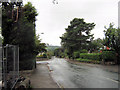
Looking down Woodhouse Lane
Looking past its junction with Smithy Lane, this the view down Woodhouse Lane to its junction with Congleton Road.
Image: © Jonathan Kington
Taken: 29 Aug 2010
0.06 miles
9

North on Congleton Road
Looking north on Congleton Road from near its junction with Smithy Lane, the tower of St Lawrence's Church can be seen in the distance.
Image: © Jonathan Kington
Taken: 29 Aug 2010
0.06 miles
10

Benchmark by Congleton Road
Although quite faint, this benchmark is still cleanly cut, it is situated by the start of the public footpath that goes to Smithy Lane. See Image for a wider view. For more information on this benchmark go to http://www.bench-marks.org.uk/bm35468 .
Image: © Jonathan Kington
Taken: 8 Sep 2010
0.07 miles