IMAGES TAKEN NEAR TO
Hawthorn Grove, STOKE-ON-TRENT, ST8 6UJ
Introduction
This page details the photographs taken nearby to Hawthorn Grove, ST8 6UJ by members of the Geograph project.
The Geograph project started in 2005 with the aim of publishing, organising and preserving representative images for every square kilometre of Great Britain, Ireland and the Isle of Man.

There are currently over 7.5m images from over14,400 individuals and you can help contribute to the project by visiting https://www.geograph.org.uk
Image Map
Images are licensed for reuse under creativecommons.org/licenses/by-sa/2.0
Notes
- Clicking on the map will re-center to the selected point.
- The higher the marker number, the further away the image location is from the centre of the postcode.
Image Listing (31 Images Found)
Images are licensed for reuse under creativecommons.org/licenses/by-sa/2.0
Image
Details
Distance
1
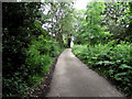
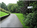
Up the hill
Looking up the private road that is also a public footpath as it heads towards Pen-y-Bont Walk.
Image: © Jonathan Kington
Taken: 28 Jun 2011
0.04 miles
2
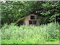
Front of the Nissen hut
A front view of Image, with large holes in its asbestos roof it is looking very dilapidated and forlorn.
The Nissen Hut was invented in 1916 by Peter Norman Nissen of the Royal Engineers. The hut was designed to be easily erected and dismantled, when it would fit into the rear of a three ton truck. To erect it would take four men six hours (although the record stood at 1hour 27minutes), and its semi-circular design helped to deflect shrapnel and the blasts from falling bombs. Made out of corrugated iron with a metal frame, it also had a wooden door and a few oiled cloth windows, instead of glass. Several huts could be fastened together to increase the size, they were used for a great number of applications from stabling horses to sleeping accommodation. For pictures showing a Nissen Hut being built visit http://www.nissens.co.uk/Working%20Drawings.htm .
Image: © Jonathan Kington
Taken: 28 Jun 2011
0.05 miles
3
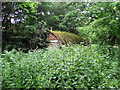
Old Nissen Hut
With its roof covered in moss and surrounded by trees, this old Nissen Hut is quietly blending into its surroundings. For another view see Image
The Nissen Hut was invented in 1916 by Peter Norman Nissen of the Royal Engineers. The hut was designed to be easily erected and dismantled, when it would fit into the rear of a three ton truck. To erect it would take four men six hours (although the record stood at 1hour 27minutes), and its semi-circular design helped to deflect shrapnel and the blasts from falling bombs. Made out of corrugated iron with a metal frame, it also had a wooden door and a few oiled cloth windows, instead of glass. Several huts could be fastened together to increase the size, they were used for a great number of applications from stabling horses to sleeping accommodation. For pictures showing a Nissen Hut being built visit http://www.nissens.co.uk/Working%20Drawings.htm .
Image: © Jonathan Kington
Taken: 28 Jun 2011
0.05 miles
4
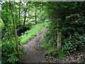
Start of the footpath
The public footpath leaves the private road and leads to Rock End with an optional path going to the Wickenstones.
Image: © Jonathan Kington
Taken: 28 Jun 2011
0.06 miles
5
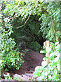
Holly tunnel
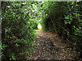
Shortly after leaving the private road to Coppice Wood (Image) the path climbs a short hill and appears to enter a tunnel created by the Holly bushes on each side.
Image: © Jonathan Kington
Taken: 28 Jun 2011
0.06 miles
6
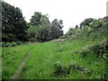
Behind the houses
At this point the path runs behind the houses on Pen-y-Bont Walk, the masses of brambles and wild roses offer plenty of security.
Image: © Jonathan Kington
Taken: 28 Jun 2011
0.09 miles
7
Along the lane
Looking along the private road that is a public footpath towards the top end of Coppice Wood.
Image: © Jonathan Kington
Taken: 28 Jun 2011
0.11 miles
8
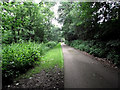
Private road
This private road allows access to the properties on this side of the valley, it is also a public footpath that leads to Mossfield Road.
Image: © Jonathan Kington
Taken: 10 Sep 2010
0.12 miles
9
Footpath to Cornfield Road
This is the start of the footpath that crosses the valley from The Nursery, through the top of Coppice Wood to Cornfield Road.
Image: © Jonathan Kington
Taken: 10 Sep 2010
0.16 miles
10
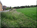
Behind Ruthin Grove
Looking along the field headland behind the houses on Ruthin Grove. The Wickenstones are just visible on the horizon.
Image: © Jonathan Kington
Taken: 20 Jul 2011
0.17 miles