IMAGES TAKEN NEAR TO
Beaumont Close, STOKE-ON-TRENT, ST8 6TE
Introduction
This page details the photographs taken nearby to Beaumont Close, ST8 6TE by members of the Geograph project.
The Geograph project started in 2005 with the aim of publishing, organising and preserving representative images for every square kilometre of Great Britain, Ireland and the Isle of Man.

There are currently over 7.5m images from over14,400 individuals and you can help contribute to the project by visiting https://www.geograph.org.uk
Image Map
Images are licensed for reuse under creativecommons.org/licenses/by-sa/2.0
Notes
- Clicking on the map will re-center to the selected point.
- The higher the marker number, the further away the image location is from the centre of the postcode.
Image Listing (86 Images Found)
Images are licensed for reuse under creativecommons.org/licenses/by-sa/2.0
Image
Details
Distance
1

Spring Grove Pumping Station
Located on Marsh Green Road and owned by United Utilities, this is a waste water pumping station and will be connected to the nearby sewage works.
Image: © Jonathan Kington
Taken: 24 Nov 2010
0.04 miles
2
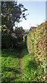
Footpath to Marsh Green
This is the start of the public footpath to Marsh Green from St. Lawrence's Church. At one time Marsh Green was a small village separated from Biddulph and this path would have given the villagers a direct route to the church.
Image: © Jonathan Kington
Taken: 13 Oct 2010
0.07 miles
3

Benchmark on St Lawrence's Church
Also visible in Image this is a good example of a cut mark, the horizontal line is used by the Ordnance Survey to give a height above sea level- in this case it is 156.94 metres. For more information see http://www.bench-marks.org.uk/bm35563 .
Image: © Jonathan Kington
Taken: 15 Sep 2010
0.10 miles
4

Tower door at St Lawrence's
This small door allows entry to the base of the tower on St Lawrence's Church and is also visible in Image To the right of the door can be seen a benchmark, for a close-up of this cut mark see Image
Image: © Jonathan Kington
Taken: 15 Sep 2010
0.10 miles
5
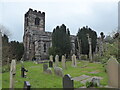
St Lawrence's Church: West end
Looking at the West entrance to St Lawrence's Church, the parish church for Biddulph (see also Image). To the right of the door at the bottom of the tower is a benchmark seen in Image and Image
Image: © Jonathan Kington
Taken: 15 Sep 2010
0.10 miles
6
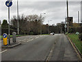
North along Congleton Road
The view towards Congleton as seen from the junction of Woodhouse Lane (Image). The church on the right is Saint Lawrence's, the parish church for Biddulph North.
Image: © Jonathan Kington
Taken: 25 Nov 2009
0.10 miles
7
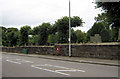
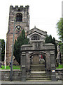
The churchyard wall
Looking across Congleton Road towards St Lawrence's Churchyard. The letterbox set in the wall is of George VI's era (see Image for a close-up)
Image: © Jonathan Kington
Taken: 15 Sep 2010
0.10 miles
8

George VIth postbox at St Lawrence's
This George VI postbox is set into the wall of St Lawrence's Churchyard. For a wider view see Image
Image: © Jonathan Kington
Taken: 15 Sep 2010
0.10 miles
9
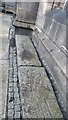
Biddulph - St Lawrence Church - Crusader grave slabs
These grave slabs are thought to be over 1000 years old.
Image: © Colin Park
Taken: 2 Jan 2017
0.10 miles