IMAGES TAKEN NEAR TO
Wedgwood Lane, STOKE-ON-TRENT, ST8 6RQ
Introduction
This page details the photographs taken nearby to Wedgwood Lane, ST8 6RQ by members of the Geograph project.
The Geograph project started in 2005 with the aim of publishing, organising and preserving representative images for every square kilometre of Great Britain, Ireland and the Isle of Man.

There are currently over 7.5m images from over14,400 individuals and you can help contribute to the project by visiting https://www.geograph.org.uk
Image Map
Images are licensed for reuse under creativecommons.org/licenses/by-sa/2.0
Notes
- Clicking on the map will re-center to the selected point.
- The higher the marker number, the further away the image location is from the centre of the postcode.
Image Listing (31 Images Found)
Images are licensed for reuse under creativecommons.org/licenses/by-sa/2.0
Image
Details
Distance
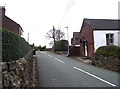
1
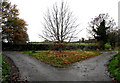
The meeting of three lanes
The picture is taken from Marshfield Lane, Wedgwood Lane goes to the left and the farm lane to Beacon House Farm is off to the right.
Image: © Jonathan Kington
Taken: 10 Nov 2010
0.13 miles
2
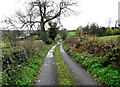
Towards the junction
Looking down Beacon House Farm lane to its junction with Wedgwood Lane and Marshfield Lane (Image).
Image: © Jonathan Kington
Taken: 10 Nov 2010
0.14 miles
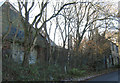
4
City Bank
Viewed from its junction with Well Lane, City Bank is a short cul-de-sac with a former textile mill located at the top. I can find no information on UK Workwear, I hope this does not mean that they are no longer trading.
Image: © Jonathan Kington
Taken: 10 Nov 2010
0.16 miles
5
Well Lane
Looking along Well Lane from its junction with Mow Lane. The red and white building on the right is another view of the Image
Image: © Jonathan Kington
Taken: 10 Nov 2010
0.17 miles
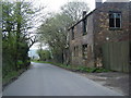
6
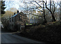
Old mill on Mow Lane
This former mill is, I believe, now used as a vehicle workshop. There is a bench mark on the nearest corner of the building (Image). For another view see Image
Image: © Jonathan Kington
Taken: 24 Nov 2010
0.17 miles
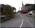
7
The old mill
Looking up Mow Lane in an opposite view of the former mill to Image The old chimney can be seen in the background.
Image: © Jonathan Kington
Taken: 24 Nov 2010
0.17 miles
8
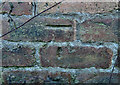
Bench mark on the old mill
This cut mark appears on the Image Before the advent of Global Positioning Systems (GPS) benchmarks were used by the Ordnance Survey to determine an accurate measurement of the height above sea-level. For more information on this and other benchmarks visit http://www.bench-marks.org.uk/bm36095 .
Image: © Jonathan Kington
Taken: 24 Nov 2010
0.17 miles
9
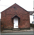
Church Mission Room
This Mission Room is located on Well Lane and was built in 1900, there is very little information on this building but I imagine it was (or is) used for Church social events. For a view of the date-stone see Image and for another view from a different angle see Image
Image: © Jonathan Kington
Taken: 10 Nov 2010
0.18 miles
10
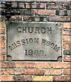
Date stone for the mission room
See Image
Image: © Jonathan Kington
Taken: 10 Nov 2010
0.18 miles