IMAGES TAKEN NEAR TO
Hollytree Drive, STOKE-ON-TRENT, ST8 6QY
Introduction
This page details the photographs taken nearby to Hollytree Drive, ST8 6QY by members of the Geograph project.
The Geograph project started in 2005 with the aim of publishing, organising and preserving representative images for every square kilometre of Great Britain, Ireland and the Isle of Man.

There are currently over 7.5m images from over14,400 individuals and you can help contribute to the project by visiting https://www.geograph.org.uk
Image Map
Images are licensed for reuse under creativecommons.org/licenses/by-sa/2.0
Notes
- Clicking on the map will re-center to the selected point.
- The higher the marker number, the further away the image location is from the centre of the postcode.
Image Listing (56 Images Found)
Images are licensed for reuse under creativecommons.org/licenses/by-sa/2.0
Image
Details
Distance
1
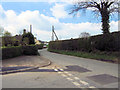
Well Lane
Looking South along Well Lane from its junction with Image
Image: © Jonathan Kington
Taken: 25 Apr 2010
0.04 miles
2
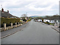
Looking down Long Valley Road
The houses on the right of the picture back on to the disused railway line that is now the Biddulph Valley Way, see Image The corner at the very bottom of the road is also visible in Image
Image: © Jonathan Kington
Taken: 25 Apr 2010
0.06 miles
3
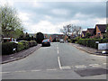
Long Valley Road
This is the junction of Long Valley Road and Well Lane, the corner in the distance is also visible at the very far end of Image
Image: © Jonathan Kington
Taken: 25 Apr 2010
0.07 miles
4
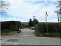
Entrance to Pointon's Plant Centre
Situated on Well Lane, this is a very well stocked family-run garden centre. see also Image
Image: © Jonathan Kington
Taken: 25 Apr 2010
0.07 miles
5
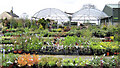
Pointon's Plant Centre
Formerly just a nursery and now open to the public, this little garden centre is very well stocked with plants and has a very friendly, knowledgeable and helpful staff.
Image: © Jonathan Kington
Taken: 25 Apr 2010
0.07 miles
6
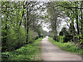
Behind Long Valley Road
Once a railway line, Biddulph Valley Way is now a popular track for walkers, horse riders and cyclists- it is also part of the Sustrans National Cycle Route 55. This is the view of where the Way goes behind the houses on Long Valley Road (Image).
Image: © Jonathan Kington
Taken: 24 Apr 2010
0.10 miles
7
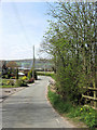
Path to Long Valley Road
This path leads from the former railway line that is now the Biddulph Valley Way to give access to Long Valley Road.
Image: © Jonathan Kington
Taken: 29 Dec 2010
0.10 miles
8
Nursery Drive
One of several cul-de-sacs that run off Long Valley Drive (see Image), the name probably comes from the nearby Plant Centre (Image).
Image: © Jonathan Kington
Taken: 25 Apr 2010
0.12 miles
9
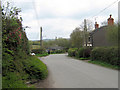
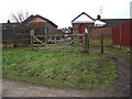
Well Lane and Marsh Green Road
The corner going off to the right marks the point where Well Lane becomes Marsh Green Road, the road bearing off to the left where the gentleman is standing is Bailey's Bank Lane and where the front of the van is visible is a farm entrance. The rocks that can be seen under the hedge on the corner mark the location of the Image
Image: © Jonathan Kington
Taken: 25 Apr 2010
0.12 miles
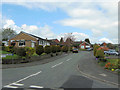
10
West on Marsh Green Road
Taken by Image and between the two gates shown in Image, this is the view West along Marsh Green Road towards the corner where the Image is located.
Image: © Jonathan Kington
Taken: 24 Apr 2010
0.13 miles