IMAGES TAKEN NEAR TO
Marsh Green Road, STOKE-ON-TRENT, ST8 6QP
Introduction
This page details the photographs taken nearby to Marsh Green Road, ST8 6QP by members of the Geograph project.
The Geograph project started in 2005 with the aim of publishing, organising and preserving representative images for every square kilometre of Great Britain, Ireland and the Isle of Man.

There are currently over 7.5m images from over14,400 individuals and you can help contribute to the project by visiting https://www.geograph.org.uk
Image Map
Images are licensed for reuse under creativecommons.org/licenses/by-sa/2.0
Notes
- Clicking on the map will re-center to the selected point.
- The higher the marker number, the further away the image location is from the centre of the postcode.
Image Listing (90 Images Found)
Images are licensed for reuse under creativecommons.org/licenses/by-sa/2.0
Image
Details
Distance
1
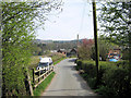
East on Marsh Green Road
Image: © Jonathan Kington
Taken: 24 Apr 2010
0.04 miles
2
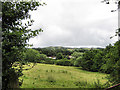
View from Biddulph Valley Way
A view across the fields with Biddulph Country Park in the middle distance and Biddulph Moor on the top of the hill.
Image: © Jonathan Kington
Taken: 12 Jul 2009
0.06 miles
3
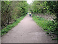
Cyclists on the Biddulph Valley Way
A former railway line, the Biddulph Valley Way is very popular with cyclists, walkers and horse riders. It is also part of Sustran's National Cycle Route 55, although I don't think these two were following the full route because I met them going in the opposite direction 10 minutes later.
Image: © Jonathan Kington
Taken: 2 May 2010
0.06 miles
4
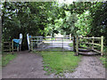
Biddulph Valley Way at Marsh Green
This is where the Biddulph Valley Way crosses Marsh Green Lane (see also Image). Biddulph Valley Way is a disused railway line converted to a public bridleway and is very popular with walkers, cyclists and horse riders.
Image: © Jonathan Kington
Taken: 12 Jul 2009
0.06 miles
5
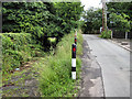
The old railway bridge
At one time traffic on Marsh Green Lane had to pass under the railway via the very low bridge on the left. When the railway was made redundant and turned into a public bridleway, instead of removing the bridge the road was diverted over the top.
Image: © Jonathan Kington
Taken: 12 Jul 2009
0.06 miles
6

Spring Grove Pumping Station
Located on Marsh Green Road and owned by United Utilities, this is a waste water pumping station and will be connected to the nearby sewage works.
Image: © Jonathan Kington
Taken: 24 Nov 2010
0.07 miles
7
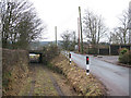
Under and over
I was mystified by why there appeared to have been both a level crossing and an underbridge where Marsh Green Road crossed the former Biddulph Valley Railway. A local contributor has given an explanation at Image
Image: © Stephen Craven
Taken: 30 Dec 2010
0.08 miles
8
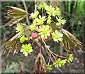
Flowers of the Norway Maple (Acer platanoides)
This is a close-up of the flowers on the Norway Maple tree shown in Image Although not native to Britain, the Norway Maple has become common enough to be called naturalised- like its cousin the Sycamore (Acer pseudoplatanus).
Image: © Jonathan Kington
Taken: 2 May 2010
0.08 miles
9
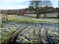
Looking across the fields
Looking from Marsh Green Road over the fields towards Biddulph Brook, on a crisp and frosty November morning. From here the brook meanders its way down the valley to Congleton where it joins the River Dane. The houses in the background face onto Congleton Road.
Image: © Jonathan Kington
Taken: 24 Nov 2010
0.09 miles
10
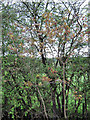
Norway Maple (Acer platanoides)
The coppery-coloured young leaves help this Norway Maple to stand out from the green Hawthorn (Crataegus monogyna) leaves behind it. Although not native to Britain, the Norway Maple has become common enough to be called naturalised- like its cousin the Sycamore (Acer pseudoplatanus). For a detailed view see Image
Image: © Jonathan Kington
Taken: 2 May 2010
0.09 miles