IMAGES TAKEN NEAR TO
Lawton Street, STOKE-ON-TRENT, ST8 6EY
Introduction
This page details the photographs taken nearby to Lawton Street, ST8 6EY by members of the Geograph project.
The Geograph project started in 2005 with the aim of publishing, organising and preserving representative images for every square kilometre of Great Britain, Ireland and the Isle of Man.

There are currently over 7.5m images from over14,400 individuals and you can help contribute to the project by visiting https://www.geograph.org.uk
Image Map
Images are licensed for reuse under creativecommons.org/licenses/by-sa/2.0
Notes
- Clicking on the map will re-center to the selected point.
- The higher the marker number, the further away the image location is from the centre of the postcode.
Image Listing (147 Images Found)
Images are licensed for reuse under creativecommons.org/licenses/by-sa/2.0
Image
Details
Distance
1
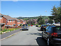
Looking down Jubilee Close
Jubilee Close is a short cul-de-sac and is shown here running towards its junction with Lawton Street.
Image: © Jonathan Kington
Taken: 16 Aug 2010
0.02 miles
3
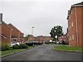
Moorland Heights
Moorland Heights is a fairly recent development of houses and apartments that overlook Biddulph Valley Park. It is a short cul-de-sac accessed from Moorland Road.
Image: © Jonathan Kington
Taken: 10 Sep 2010
0.05 miles
4
Looking up Jubilee Close
Jubilee Close is a short cul-de-sac running off Lawton Street.
Image: © Jonathan Kington
Taken: 16 Aug 2010
0.07 miles
5
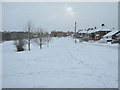
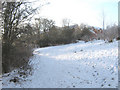
Moorland Road in Winter
Looking up a snow-covered Moorland Road after the early snows of winter 2010/11. Because this is not a designated bus route, Moorland Road does not get treated until later.
Image: © Jonathan Kington
Taken: 30 Nov 2010
0.07 miles
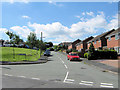
6
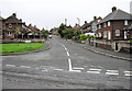
Lower end of Highfield Road East
Looking up Highfield Road East from its junction with Lawton Street, from here it climbs to join Well Street (Image) just round the corner at the top.
Image: © Jonathan Kington
Taken: 10 Sep 2010
0.07 miles
7
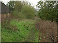
Below the garden wall
Looking north-west down Biddulph Valley Park, the wall and fence on the left belong to the rear gardens of houses on Image
Image: © Jonathan Kington
Taken: 21 Oct 2010
0.08 miles
8
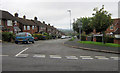
Down Moorland Road
Looking down Moorland Road from its junction with Cornfield Road.
Image: © Jonathan Kington
Taken: 10 Sep 2010
0.08 miles
9
Looking up to Moorland Heights
Viewed from the upper of the two bridges crossing the brook in Biddulph Valley Park.
Image: © Jonathan Kington
Taken: 23 Dec 2010
0.09 miles
10
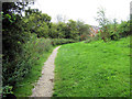
Path to Moorland Road
This path goes up the side of Biddulph Valley from the Image to Moorland Road.
Image: © Jonathan Kington
Taken: 11 Aug 2010
0.09 miles