IMAGES TAKEN NEAR TO
Moorland Road, STOKE-ON-TRENT, ST8 6EW
Introduction
This page details the photographs taken nearby to Moorland Road, ST8 6EW by members of the Geograph project.
The Geograph project started in 2005 with the aim of publishing, organising and preserving representative images for every square kilometre of Great Britain, Ireland and the Isle of Man.

There are currently over 7.5m images from over14,400 individuals and you can help contribute to the project by visiting https://www.geograph.org.uk
Image Map
Images are licensed for reuse under creativecommons.org/licenses/by-sa/2.0
Notes
- Clicking on the map will re-center to the selected point.
- The higher the marker number, the further away the image location is from the centre of the postcode.
Image Listing (208 Images Found)
Images are licensed for reuse under creativecommons.org/licenses/by-sa/2.0
Image
Details
Distance
1
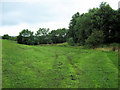
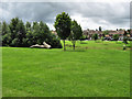
Lower end of Biddulph Valley Park
This is close to the bottom end of the park, hidden by the trees at the end is Biddulph Valley Leisure Centre.
Image: © Jonathan Kington
Taken: 13 Aug 2010
0.05 miles
2
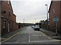
East Drive
East Drive runs from Lawton Street to Moorland Road, only about 100 metres in length- it cuts the corner close to the junction.
Image: © Jonathan Kington
Taken: 3 Sep 2010
0.06 miles
3
Southeast up Lawton Street
Looking up Lawton Street, the junction with one end of Image is visible on the right of the picture. The first house on the left has a benchmark just visible from the road.
Image: © Jonathan Kington
Taken: 19 Sep 2010
0.06 miles
4
Looking up Moorlands Road
Looking East along Moorlands Road that runs adjacent to Biddulph Valley Park.
Image: © Jonathan Kington
Taken: 7 Dec 2009
0.06 miles
5
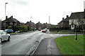
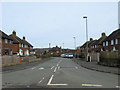
Lawton Street
This is the view looking up Lawton Street from its junction with Congleton Road.
Image: © Jonathan Kington
Taken: 23 Mar 2010
0.06 miles
6
Down Lawton Street from Kingsfield Road
Looking down Lawton Street from the roundabout in Image towards its junction with Congleton Road in Image
Image: © Jonathan Kington
Taken: 23 Mar 2010
0.06 miles
7
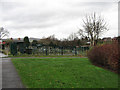
Moorlands Road Allotments
A small area of land, belonging to the Town Council, that was originally allotments and then was subject to a planning application for housing. When this proposal was rejected it reverted to allotments after it was allowed to turn into a bit of a wilderness, with some very productive work being carried out on them.
Image: © Jonathan Kington
Taken: 7 Dec 2009
0.07 miles
8
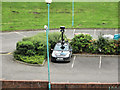
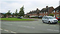
What is he doing back here?
Parked in the car-park of Biddulph Valley Leisure Centre was this Google Streetview camera car, considering that all the streets and roads here in Biddulph are covered it seems a bit strange that they have returned so soon.
Image: © Jonathan Kington
Taken: 6 Sep 2010
0.07 miles
9
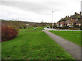
Looking across Biddulph Valley
Biddulph Valley is maintained as part public park and part wildlife area (see also Image).
Image: © Jonathan Kington
Taken: 12 Jul 2009
0.07 miles
10
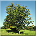
Autumn is coming
It's not even September and this Acer in Biddulph Valley Park is already starting to change colour. Biddulph Valley Park is an open area partly managed for public amenity and partly for wildlife.
Image: © Jonathan Kington
Taken: 30 Aug 2010
0.08 miles