IMAGES TAKEN NEAR TO
Turner Avenue, STOKE-ON-TRENT, ST7 8PF
Introduction
This page details the photographs taken nearby to Turner Avenue, ST7 8PF by members of the Geograph project.
The Geograph project started in 2005 with the aim of publishing, organising and preserving representative images for every square kilometre of Great Britain, Ireland and the Isle of Man.

There are currently over 7.5m images from over14,400 individuals and you can help contribute to the project by visiting https://www.geograph.org.uk
Image Map
Images are licensed for reuse under creativecommons.org/licenses/by-sa/2.0
Notes
- Clicking on the map will re-center to the selected point.
- The higher the marker number, the further away the image location is from the centre of the postcode.
Image Listing (16 Images Found)
Images are licensed for reuse under creativecommons.org/licenses/by-sa/2.0
Image
Details
Distance
1
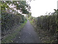
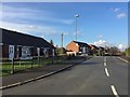
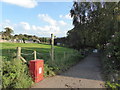
Wood Lane: path along north side of village
On the left are houses and on the right open fields.
Image: © Jonathan Hutchins
Taken: 15 Oct 2016
0.07 miles
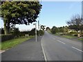
9
Wood Lane: footpath off Apedale Road
The footpath leads to Apedale Country Park.
Image: © Jonathan Hutchins
Taken: 15 Oct 2016
0.20 miles
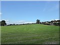
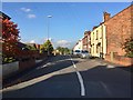
10
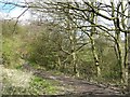
Footpath at Wood Lane
View from the footpath looking towards the houses at Wood Lane, just about visible through the trees.
Image: © Steve Lewin
Taken: 11 Apr 2007
0.21 miles