IMAGES TAKEN NEAR TO
Heathcote Road, STOKE-ON-TRENT, ST7 8BH
Introduction
This page details the photographs taken nearby to Heathcote Road, ST7 8BH by members of the Geograph project.
The Geograph project started in 2005 with the aim of publishing, organising and preserving representative images for every square kilometre of Great Britain, Ireland and the Isle of Man.

There are currently over 7.5m images from over14,400 individuals and you can help contribute to the project by visiting https://www.geograph.org.uk
Image Map
Images are licensed for reuse under creativecommons.org/licenses/by-sa/2.0
Notes
- Clicking on the map will re-center to the selected point.
- The higher the marker number, the further away the image location is from the centre of the postcode.
Image Listing (77 Images Found)
Images are licensed for reuse under creativecommons.org/licenses/by-sa/2.0
Image
Details
Distance
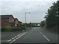
1
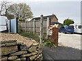
Entrance to public footpath in Halmer End
This is designated Audley 105: see https://www.geograph.org.uk/photo/7354215 and https://www.geograph.org.uk/photo/7354214
Image: © Jonathan Hutchins
Taken: 27 Nov 2022
0.02 miles
2
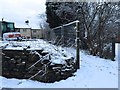
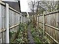
Halmer End: footpath next to building site
This is FP Audley 105, which runs for all of 43m between Heathcote Road and the High Street.
Image: © Jonathan Hutchins
Taken: 30 Jan 2015
0.03 miles
4
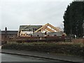
Halmer End: impending construction work
For a view eleven months later see http://www.geograph.org.uk/photo/4762313
Image: © Jonathan Hutchins
Taken: 30 Jan 2015
0.03 miles
5
Halmer End: house under construction
For a view eleven months earlier see http://www.geograph.org.uk/photo/4328938
Image: © Jonathan Hutchins
Taken: 10 Dec 2015
0.03 miles
6
Cut-through in Halmer End
This very short and probably little-used public footpath. designated Audley 105, acts as a cut-through between Halmer End High Street and Heathcote Road.
Image: © Jonathan Hutchins
Taken: 27 Nov 2022
0.03 miles
7
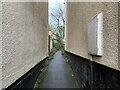
Cut-through in Halmer End
This very short and probably little-used public footpath. designated Audley 105, acts as a cut-through between Halmer End High Street and Heathcote Road.
Image: © Jonathan Hutchins
Taken: 27 Nov 2022
0.04 miles
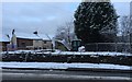
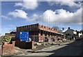
8
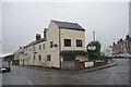
Halmer End: junction of High Street and Heathcote Road
This building was once the home of Rileys ironmongers and seedsmen. The firm has now moved to the opposite side of the road - see http://www.geograph.org.uk/photo/4489515. Later it housed a vegetarian restaurant called The Bosted Onion until about 2008, but is now given over entirely to residential use.
Image: © Jonathan Hutchins
Taken: 24 May 2015
0.04 miles
9
Halmer End: junction of Heathcote Road and Lynsey Close
Image: © Jonathan Hutchins
Taken: 16 Jun 2015
0.06 miles
10
Halmer End: houses under construction
Compare Image taken two years earlier when this was still a grassy plot awaiting sale. The white gable end and brick chimney of the building on the right can be seen in both photos.
The completed houses can be seen in https://www.geograph.org.uk/photo/5683517
Image: © Jonathan Hutchins
Taken: 4 Mar 2017
0.06 miles