
IMAGES TAKEN NEAR TO
Shraley Brook Road, STOKE-ON-TRENT, ST7 8AH
Introduction
This page details the photographs taken nearby to Shraley Brook Road, ST7 8AH by members of the Geograph project.
The Geograph project started in 2005 with the aim of publishing, organising and preserving representative images for every square kilometre of Great Britain, Ireland and the Isle of Man.

There are currently over 7.5m images from over14,400 individuals and you can help contribute to the project by visiting https://www.geograph.org.uk
Image Map
Images are licensed for reuse under creativecommons.org/licenses/by-sa/2.0
Notes
- Clicking on the map will re-center to the selected point.
- The higher the marker number, the further away the image location is from the centre of the postcode.
Image Listing (129 Images Found)
Images are licensed for reuse under creativecommons.org/licenses/by-sa/2.0
Image
Details
Distance

2

Halmer End: demolished wall of former railway bridge
This was removed early in 2015. The retaining wall on the opposite side of the road is still in situ, see http://www.geograph.org.uk/photo/4415154.
Image: © Jonathan Hutchins
Taken: 5 Apr 2015
0.04 miles
3
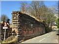
Halmer End: retaining wall of former railway bridge
Here the railway crossed Shraleybrook Road. The corresponding wall on the other side of the road was dismantled early in 2015; see http://www.geograph.org.uk/photo/4415158.
Image: © Jonathan Hutchins
Taken: 5 Apr 2015
0.05 miles
4
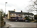
The Railway Hotel, Halmer End
Across the road from the site of the former Halmerend station.
Image: © Stephen Craven
Taken: 29 Dec 2018
0.07 miles
5
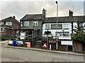
The Railway, Halmer End
The inn presents a very different appearance from its 2015 incarnation https://www.geograph.org.uk/photo/4532734
In addition it now hosts the local outlet of OatCuisine, the business having vacated its corner-shop premises a short distance away in Miles Green https://www.geograph.org.uk/photo/4427262
Image: © Jonathan Hutchins
Taken: 3 Dec 2022
0.07 miles
6

Birch bog at Bateswood Country Park
Image: © Jonathan Hutchins
Taken: 8 Apr 2018
0.07 miles
7
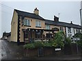
Halmer End: The Railway
The pub was so named after the Audley branch line which crossed the adjacent road by a bridge. The remains of the retaining wall a short distance down the road to the right can be seen in http://www.geograph.org.uk/photo/4415154.
For a 2022 view of the same pub see https://www.geograph.org.uk/photo/7356722
Image: © Jonathan Hutchins
Taken: 20 Jun 2015
0.08 miles
8

Ditch at edge of Bateswood Country Park
Image: © Jonathan Hutchins
Taken: 8 Apr 2018
0.08 miles
9

Halmer End: junction of Red Hall Lane with Shraleybrook Road
The signpost indicates the route of footpath Audley 58, which follows the same route as Red Hall Lane. The electricity substation on the poles has the substation I.D. 2751771 and designation 'Minnie Farm' on the Western Power database; it is an 11kV substation with 1030kW capacity.
Image: © Jonathan Hutchins
Taken: 5 Apr 2015
0.09 miles
