IMAGES TAKEN NEAR TO
High View, STOKE-ON-TRENT, ST7 4YE
Introduction
This page details the photographs taken nearby to High View, ST7 4YE by members of the Geograph project.
The Geograph project started in 2005 with the aim of publishing, organising and preserving representative images for every square kilometre of Great Britain, Ireland and the Isle of Man.

There are currently over 7.5m images from over14,400 individuals and you can help contribute to the project by visiting https://www.geograph.org.uk
Image Map
Images are licensed for reuse under creativecommons.org/licenses/by-sa/2.0
Notes
- Clicking on the map will re-center to the selected point.
- The higher the marker number, the further away the image location is from the centre of the postcode.
Image Listing (8 Images Found)
Images are licensed for reuse under creativecommons.org/licenses/by-sa/2.0
Image
Details
Distance
2
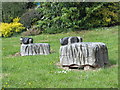
Sheep on Village Green
Carved wooden sheep on Mount Pleasant village green (sadly one of three has been vandalised - not in photo). See also Image
Image: © Martin Lack
Taken: 26 May 2009
0.06 miles
3
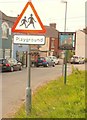
Playground for the not-so-rich
Mt Pleasant Village Green (very popular during half term).
See also Image
Image: © Martin Lack
Taken: 26 May 2009
0.10 miles
5
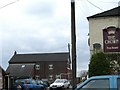
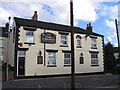
Chapel St, Mount Pleasant
To the left is the Mount Pleasant Primitive Methodist Chapel, built in 1856. The Crown public house on the right is somewhat newer.
Image: © Steve Lewin
Taken: 26 Apr 2006
0.14 miles
6
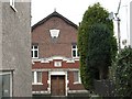
Chapel, Mount Pleasant
Details of the front of the Mount Pleasant Methodist Chapel taken from Church Street.
Image: © Steve Lewin
Taken: 26 Apr 2006
0.14 miles