IMAGES TAKEN NEAR TO
Beech Avenue, STOKE-ON-TRENT, ST7 3SH
Introduction
This page details the photographs taken nearby to Beech Avenue, ST7 3SH by members of the Geograph project.
The Geograph project started in 2005 with the aim of publishing, organising and preserving representative images for every square kilometre of Great Britain, Ireland and the Isle of Man.

There are currently over 7.5m images from over14,400 individuals and you can help contribute to the project by visiting https://www.geograph.org.uk
Image Map
Images are licensed for reuse under creativecommons.org/licenses/by-sa/2.0
Notes
- Clicking on the map will re-center to the selected point.
- The higher the marker number, the further away the image location is from the centre of the postcode.
Image Listing (5 Images Found)
Images are licensed for reuse under creativecommons.org/licenses/by-sa/2.0
Image
Details
Distance
2
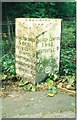
Old Milepost by the A50 in Rode Heath
Cast iron post by the A50, in parish of Odd Rode (Congleton District), North of Rode Heath, in pavement, back to wire fence, on West side of road. Cast iron CCC1898, erected by the County Council in the 19th century.
Inscription reads:-
: BRERETON GREEN / 5 MILES / HOLMES / CHAPEL 7 / KNUTSFORD 15 / WARRINGTON 26 / LIVERPOOL 45 : : CHESHIRE / 1898 / COUNTY COUNCIL : : CHURCH LAWTON / 1 MILE / NEWCASTLE / 8 :
Maker:-
: W H SMITH & CO / MAKERS / WHITCHURCH :
Milestone Society National ID: CH_NCWA08
Image: © J Higgins
Taken: 1 May 2003
0.05 miles
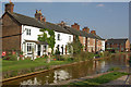
4
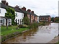
Canalside housing above Lock 53, Trent and Mersey Canal
Image: © David Martin
Taken: 5 Aug 2010
0.24 miles
5
Trent & Mersey Canal, Rode Heath
A row of houses immediately above Thurlwood Lock, no 53.
Image: © Stephen McKay
Taken: 2 Sep 2010
0.24 miles