IMAGES TAKEN NEAR TO
Poolside, STOKE-ON-TRENT, ST7 3QS
Introduction
This page details the photographs taken nearby to Poolside, ST7 3QS by members of the Geograph project.
The Geograph project started in 2005 with the aim of publishing, organising and preserving representative images for every square kilometre of Great Britain, Ireland and the Isle of Man.

There are currently over 7.5m images from over14,400 individuals and you can help contribute to the project by visiting https://www.geograph.org.uk
Image Map
Images are licensed for reuse under creativecommons.org/licenses/by-sa/2.0
Notes
- Clicking on the map will re-center to the selected point.
- The higher the marker number, the further away the image location is from the centre of the postcode.
Image Listing (12 Images Found)
Images are licensed for reuse under creativecommons.org/licenses/by-sa/2.0
Image
Details
Distance
1
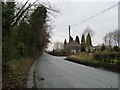
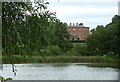
House at the 89 metre spot height
At the junction of Pool Side and Townsend Lane.
Image: © Christine Johnstone
Taken: 15 Dec 2013
0.00 miles
2
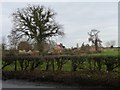
Ivy-covered tree, along Townsend Lane
Townsend Farm is the building on the horizon, behind the second tree.
Image: © Christine Johnstone
Taken: 15 Dec 2013
0.04 miles
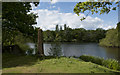
4
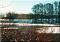
Rode Pool in winter
Looking towards Mow Cop across the frozen lake
Image: © John Naisbitt
Taken: Unknown
0.07 miles
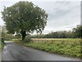
7
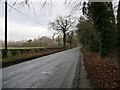
Pool Side, looking north-east
The name of the road on the western bank of Rode Pool.
Image: © Christine Johnstone
Taken: 15 Dec 2013
0.09 miles
8
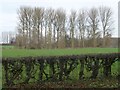
Small wood by a pond, south-east of Townsend Farm
Seen from the road called Pool Side, north of Rode Pool.
Image: © Christine Johnstone
Taken: 15 Dec 2013
0.10 miles
9
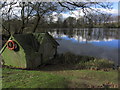
Rode Pool & Boathouse, Rode Hall near Alsager
Image: © Colin Park
Taken: 1 Mar 2014
0.13 miles
10
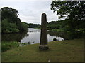
Rode Hall Obelisk
A small obelisk on the banks of Rode Pool at Rode Hall
Image: © Paul Brooker
Taken: 15 Jun 2011
0.14 miles