IMAGES TAKEN NEAR TO
Woodside Cottages, STOKE-ON-TRENT, ST7 3PQ
Introduction
This page details the photographs taken nearby to Woodside Cottages, ST7 3PQ by members of the Geograph project.
The Geograph project started in 2005 with the aim of publishing, organising and preserving representative images for every square kilometre of Great Britain, Ireland and the Isle of Man.

There are currently over 7.5m images from over14,400 individuals and you can help contribute to the project by visiting https://www.geograph.org.uk
Image Map
Images are licensed for reuse under creativecommons.org/licenses/by-sa/2.0
Notes
- Clicking on the map will re-center to the selected point.
- The higher the marker number, the further away the image location is from the centre of the postcode.
Image Listing (96 Images Found)
Images are licensed for reuse under creativecommons.org/licenses/by-sa/2.0
Image
Details
Distance
1

Mow Cop Folly
Built on the border between Staffordshire and Cheshire, the Gritstone Trail and South Cheshire way meet here.
Image: © Richard Styles
Taken: 27 Dec 2006
0.04 miles
2
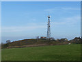
Mow Cop transmitter
The site was formerly Ministry of Defence, having been used for a radio jamming station in WW2, but is now a DAB radio transmitter.
Image: © Stephen Craven
Taken: 24 Feb 2019
0.05 miles
3
Mow Cop transmitter
The site was formerly Ministry of Defence, having been used for a radio jamming station in WW2, but is now a DAB radio transmitter. see Image for a view with wider context.
Image: © Stephen Craven
Taken: 16 Oct 2021
0.05 miles
4
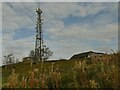
Telecoms mast at Mow Cop
Sited on the top of the ridge overlooking the Cheshire Plain. The clouds are producing frequent showers.
Image: © Bill Boaden
Taken: 19 Jun 2020
0.05 miles
5

Old Boundary Marker close to the Old Man of Mow
County Boundary Marker on moorland close to the Old Man of Mow. On the boundary of Odd Rode, Cheshire and Kidsgrove, Staffordshire. Inscribed C and S on each face.
Milestone Society National ID: CH_OROKID01cb
Image: © J Glew
Taken: 9 Aug 2019
0.06 miles
6
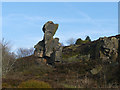
An inaccessible pinnacle
Forget An Stac on Skye.. This quarry remnant looming over the triangulation pillar is at least VS and a nanny dodge to get up. Probably a very traditional VS too. It is said to be in danger of falling, hence the defences around its base.
VS is a climbing grade - very severe. Nowadays that is considered more or less the top end of the easy stuff. Traditional VS is an ominous term. Once VS was the top of the grades, so the hard stuff got that grade as well, even though very much more difficult than your standard Very Severe.
Image: © Richard Webb
Taken: 1 Apr 2004
0.07 miles
8
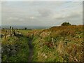
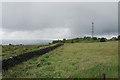
Stile below Daisy Bank Farm
The stile is on the South Cheshire Way.
Image: © Stephen Craven
Taken: 16 Oct 2021
0.07 miles
9
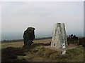
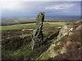
The Old Man of Mow
A rock outcrop left standing by surrounding quarrying. Now in the care of the National Trust.
Image: © Stephen Craven
Taken: 24 Feb 2019
0.07 miles
10
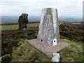
The Old Man Mow Cop Plus Trig
Stood on trig before base jumping off it in a sad attempt to be higher than The Old Man of Mow for a second on grey dry afternoon.
Name: Mow Cop
Hill number: 2826
Height: 337m / 1106ft
Area: 36: Lancashire, Cheshire & the Southern Pennines
Class: Hu,sMa
Grid ref: SJ 85830 57561
Summit feature: The Old Man
Drop: 143m
Col: 194m SJ878567
Image: © Rude Health
Taken: 31 Oct 2010
0.08 miles