
IMAGES TAKEN NEAR TO
Daisy Bank, STOKE-ON-TRENT, ST7 3PN
Introduction
This page details the photographs taken nearby to Daisy Bank, ST7 3PN by members of the Geograph project.
The Geograph project started in 2005 with the aim of publishing, organising and preserving representative images for every square kilometre of Great Britain, Ireland and the Isle of Man.

There are currently over 7.5m images from over14,400 individuals and you can help contribute to the project by visiting https://www.geograph.org.uk
Image Map
Images are licensed for reuse under creativecommons.org/licenses/by-sa/2.0
Notes
- Clicking on the map will re-center to the selected point.
- The higher the marker number, the further away the image location is from the centre of the postcode.
Image Listing (40 Images Found)
Images are licensed for reuse under creativecommons.org/licenses/by-sa/2.0
Image
Details
Distance
1
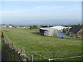
Field at Daisy Bank Farm
From a distance it looks like a field of daisies, but closer up the white dots are actually pellets of dried manure.
Image: © Stephen Craven
Taken: 24 Feb 2019
0.02 miles
2
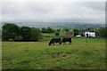
Cattle near Daisy Bank Farm
The Staffordshire side of the Gritstone Trail which is following a ridge. The weather is producing frequent showers.
Image: © Bill Boaden
Taken: 19 Jun 2020
0.03 miles
3
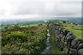
The Gritstone Trail near Mow Cop
The path is following a gently descending ridge. The wall is the boundary between Cheshire and Staffordshire. Rain clouds loom ahead.
Image: © Bill Boaden
Taken: 19 Jun 2020
0.04 miles
4
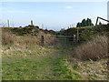
Former quarry access behind Daisy Bank Farm
The track appears to have been worn down as a holloway by the passage of countless wagons of stone.
Image: © Stephen Craven
Taken: 24 Feb 2019
0.04 miles
5
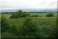
Ridge top near Mow Cop
The Cheshire side of the ridge, which marks the boundary between Cheshire and Staffordshire.
Image: © Bill Boaden
Taken: 19 Jun 2020
0.04 miles
6
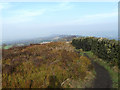
The Gritstone Trail at Mow Cop
From a local summit of 325m altitude, looking roughly north along the ridge towards Bosley Cloud. This ridge forms the county boundary between Cheshire and Staffordshire.
Image: © Stephen Craven
Taken: 24 Feb 2019
0.04 miles
7
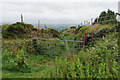
Farm track near Daisy Bank Farm
Leading off the top of the ridge along which the Gritstone Trail runs. I am standing in Cheshire while the track is in Staffordshire.
Image: © Bill Boaden
Taken: 19 Jun 2020
0.05 miles
8

Former quarry behind Daisy Bank Farm
The path is part of the Gritstone Trail.
Image: © Stephen Craven
Taken: 24 Feb 2019
0.06 miles
9
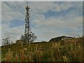
Mow Cop transmitter
The site was formerly Ministry of Defence, having been used for a radio jamming station in WW2, but is now a DAB radio transmitter. see Image for a view with wider context.
Image: © Stephen Craven
Taken: 16 Oct 2021
0.07 miles
10

Mow Cop transmitter
The site was formerly Ministry of Defence, having been used for a radio jamming station in WW2, but is now a DAB radio transmitter.
Image: © Stephen Craven
Taken: 24 Feb 2019
0.07 miles