IMAGES TAKEN NEAR TO
Audley Road, STOKE-ON-TRENT, ST7 2QN
Introduction
This page details the photographs taken nearby to Audley Road, ST7 2QN by members of the Geograph project.
The Geograph project started in 2005 with the aim of publishing, organising and preserving representative images for every square kilometre of Great Britain, Ireland and the Isle of Man.

There are currently over 7.5m images from over14,400 individuals and you can help contribute to the project by visiting https://www.geograph.org.uk
Image Map
Images are licensed for reuse under creativecommons.org/licenses/by-sa/2.0
Notes
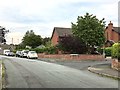
- Clicking on the map will re-center to the selected point.
- The higher the marker number, the further away the image location is from the centre of the postcode.
Image Listing (76 Images Found)
Images are licensed for reuse under creativecommons.org/licenses/by-sa/2.0
Image
Details
Distance
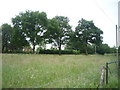
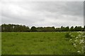
2
Alsager: field off Fanny's Croft (3)
Image: © Jonathan Hutchins
Taken: 25 May 2015
0.09 miles
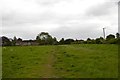
5
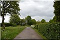
Alsager: Fanny's Croft
A private road but a public footpath.
Image: © Jonathan Hutchins
Taken: 25 May 2015
0.09 miles
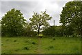
6
Alsager: field off Fanny's Croft (4)
Image: © Jonathan Hutchins
Taken: 25 May 2015
0.10 miles
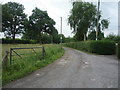
7
Alsager: entrance to field off Fanny's Croft
Image: © Jonathan Hutchins
Taken: 25 May 2015
0.10 miles
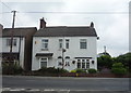
8
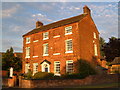
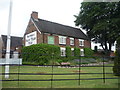
The Town House, Alsager
This fine Georgian building on the Audley Road at the south end of Alsager is now a day nursery. http://www.britishlistedbuildings.co.uk/en-56472-townhouse-farmhouse-alsager
Image: © Derek Harper
Taken: 29 Jun 2006
0.11 miles
9
Junction of Birch Avenue and Yew Tree Close, Alsager
Image: © Jonathan Hutchins
Taken: 6 Jul 2017
0.11 miles
10
Stables Bar & Grill, Best Western Manor House Hotel
Image: © JThomas
Taken: 11 Jun 2016
0.12 miles