IMAGES TAKEN NEAR TO
Barratt Road, STOKE-ON-TRENT, ST7 2PY
Introduction
This page details the photographs taken nearby to Barratt Road, ST7 2PY by members of the Geograph project.
The Geograph project started in 2005 with the aim of publishing, organising and preserving representative images for every square kilometre of Great Britain, Ireland and the Isle of Man.

There are currently over 7.5m images from over14,400 individuals and you can help contribute to the project by visiting https://www.geograph.org.uk
Image Map
Images are licensed for reuse under creativecommons.org/licenses/by-sa/2.0
Notes
- Clicking on the map will re-center to the selected point.
- The higher the marker number, the further away the image location is from the centre of the postcode.
Image Listing (24 Images Found)
Images are licensed for reuse under creativecommons.org/licenses/by-sa/2.0
Image
Details
Distance
1
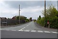
Alsager: junction of Linley Road and Barratt Road
Image: © Jonathan Hutchins
Taken: 28 May 2016
0.08 miles
2

Cardway, Alsager
The company makes packaging materials in a factory on the site of a former railway wagon works.
Image: © Stephen Craven
Taken: 28 Dec 2024
0.10 miles
3

Former railway house at the end of Foden Avenue
The building is within the curtilage of the former railway wagon works. It appears on the 1955 1:2500 map (but not earlier editions).
Image: © Stephen Craven
Taken: 28 Dec 2024
0.10 miles
4
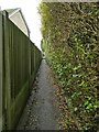
Path from Linley Lane to Foden Avenue
A convenient shortcut for residents on foot.
Image: © Stephen Craven
Taken: 28 Dec 2024
0.11 miles
5
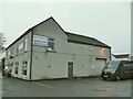
Newcastle Plumbing
A bathroom showroom on the corner of Linley Lane and Linley Road in Alsager.
Image: © Stephen Craven
Taken: 28 Dec 2024
0.12 miles
6
Sewage pumping station on Linley Grove
The concrete slab with access covers, and the 'stink pipe', are giveaways.
Image: © Stephen Craven
Taken: 28 Dec 2024
0.12 miles
7

Junction of Linley Lane and Linley Road in Alsager
Linley Lane is part of the A5011.
Image: © Stephen Craven
Taken: 28 Dec 2024
0.13 miles
8
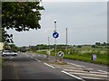
Alsager: junction of Linley Road and the A5011
A notice opposite the entrance to Linley Road warns CRASH HOT SPOT - LOOK BOTH WAYS AND KEEP LOOKING. Traffic can whizz by either way very quickly on the A5011 at this point.
Image: © Jonathan Hutchins
Taken: 28 May 2016
0.14 miles
9
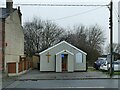
Alsager Seventh Day Adventist Church
The small chapel is not shown on pre-WWII maps but is shown as a 'hall' on post-war maps. The 'Seventh Day' in the church's name indicates that they worship on the Jewish Shabbat rather than on Sunday, and indeed a prayer meeting was in progress on this Saturday afternoon.
Image: © Stephen Craven
Taken: 28 Dec 2024
0.14 miles
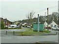
10
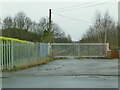
Network Rail access point, Alsager Junction
An electrification gantry on the Crewe to Kidsgrove line can be seen in the distance.
Image: © Stephen Craven
Taken: 28 Dec 2024
0.15 miles