IMAGES TAKEN NEAR TO
Cranberry Lane, STOKE-ON-TRENT, ST7 2LF
Introduction
This page details the photographs taken nearby to Cranberry Lane, ST7 2LF by members of the Geograph project.
The Geograph project started in 2005 with the aim of publishing, organising and preserving representative images for every square kilometre of Great Britain, Ireland and the Isle of Man.

There are currently over 7.5m images from over14,400 individuals and you can help contribute to the project by visiting https://www.geograph.org.uk
Image Map
Images are licensed for reuse under creativecommons.org/licenses/by-sa/2.0
Notes
- Clicking on the map will re-center to the selected point.
- The higher the marker number, the further away the image location is from the centre of the postcode.
Image Listing (11 Images Found)
Images are licensed for reuse under creativecommons.org/licenses/by-sa/2.0
Image
Details
Distance
2
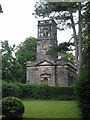
Christ Church Alsager
The first of two Anglian church buildings in the small town of Alsager.
Built and endowed in the year 1789 by three sisters, Margaret, Judith and Mary Alsager, of the Manor of Alsager. It is in the Palladin style popular in the late c18th.
The mother church at that time was the church in Barthomley, now a much smaller community than Alsager, and being three miles distant, with the roads very bad between, Christ Church was built for the convenience and comfort of tenants and others who found it difficult to attend at Barthomley.
Image: © Dennis Thorley
Taken: 11 Jul 2005
0.13 miles
3
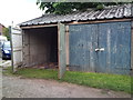
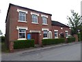
Lock-up garages off Coronation Avenue, Alsager
Image: © Jonathan Hutchins
Taken: 24 Jul 2011
0.16 miles
4
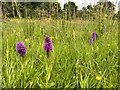
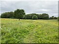
Orchids in grassland off Crewe Road
The two plants in the foreground are possibly Southern Marsh Orchid, while the more distant ones to the right are probably Common Spotted Orchid, but hybrids are so frequent in this area that I.D. is difficult.
Image: © Jonathan Hutchins
Taken: 6 Jun 2023
0.17 miles
6
Alsager: Hassall Road Methodist Church, now a bookshop
The church was established in 1834 to meet the needs of Methodists in the small community of Alsager, who had previously met in a loom shop. It was originally established as a one-room chapel in what is now the Sunday school, on a plot donated by Alsager land-owner John Plant. In 1852, a new church building was erected on the site to meet growing demand, as Alsager grew alongside the railways.
In about 1912, the Methodist church at Wesley Place was opened to serve the other end of Alsager, with the older, smaller church retained and refurbished to serve the largely farming community.
It closed as a place of worship on 13th December 2009.
A blog entry written by a bookshop volunteer: https://alsagerbookemporium.wordpress.com/2016/03/01/how-did-it-all-start/
Image: © Jonathan Hutchins
Taken: 26 May 2016
0.19 miles
7
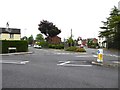
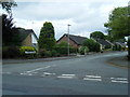
Alsager: junction of Hassall Road, Chancery Lane and Crewe Road
Image: © Jonathan Hutchins
Taken: 26 May 2016
0.20 miles

9
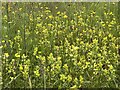
Abundant Yellow-rattle in grass
The Yellow-rattle even outnumbered the Meadow Buttercups, also visible in this photograph. A view of the grassland site itself is here https://www.geograph.org.uk/photo/7672628
Image: © Jonathan Hutchins
Taken: 6 Jun 2023
0.20 miles
10
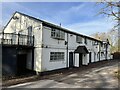
The Old Mill near Alsager
This pub closed at the time of the first Covid lockdown and also has sustained some flood damage (as its name suggests, part of the building is an old watermill). As of Feb 2023 it remains closed and in need of restoration.
Image: © Jonathan Hutchins
Taken: 5 Feb 2023
0.23 miles