IMAGES TAKEN NEAR TO
Crewe Road, STOKE-ON-TRENT, ST7 2JE
Introduction
This page details the photographs taken nearby to Crewe Road, ST7 2JE by members of the Geograph project.
The Geograph project started in 2005 with the aim of publishing, organising and preserving representative images for every square kilometre of Great Britain, Ireland and the Isle of Man.

There are currently over 7.5m images from over14,400 individuals and you can help contribute to the project by visiting https://www.geograph.org.uk
Image Map
Images are licensed for reuse under creativecommons.org/licenses/by-sa/2.0
Notes
- Clicking on the map will re-center to the selected point.
- The higher the marker number, the further away the image location is from the centre of the postcode.
Image Listing (20 Images Found)
Images are licensed for reuse under creativecommons.org/licenses/by-sa/2.0
Image
Details
Distance
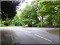
1
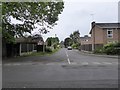
Alsager: Church Road junction with The Gables
Image: © Jonathan Hutchins
Taken: 26 May 2016
0.10 miles
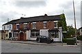
4
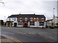
Alsager, The Lodge
Public house at the corner of Crewe and Station Roads; internally, two simple, traditional rooms, wooden panelling and open fires. The pub specialises in beers from micro-breweries: at my visit, Kelham Island Fairytale, Oakham Citra and Whims Flower Power were on offer. Listed in the 2013 Good Beer Guide. For some customer comments, see http://www.beerintheevening.com/pubs/s/20/20425/Lodge_Inn/Alsager
Image: © Mike Faherty
Taken: 23 Dec 2012
0.14 miles
5
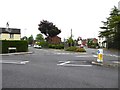
Alsager: junction of Hassall Road, Chancery Lane and Crewe Road
Image: © Jonathan Hutchins
Taken: 26 May 2016
0.14 miles
6
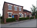
Alsager: Hassall Road Methodist Church, now a bookshop
The church was established in 1834 to meet the needs of Methodists in the small community of Alsager, who had previously met in a loom shop. It was originally established as a one-room chapel in what is now the Sunday school, on a plot donated by Alsager land-owner John Plant. In 1852, a new church building was erected on the site to meet growing demand, as Alsager grew alongside the railways.
In about 1912, the Methodist church at Wesley Place was opened to serve the other end of Alsager, with the older, smaller church retained and refurbished to serve the largely farming community.
It closed as a place of worship on 13th December 2009.
A blog entry written by a bookshop volunteer: https://alsagerbookemporium.wordpress.com/2016/03/01/how-did-it-all-start/
Image: © Jonathan Hutchins
Taken: 26 May 2016
0.14 miles
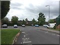
8
Alsager: junction of Church Road and Lodge Road
Image: © Jonathan Hutchins
Taken: 26 May 2016
0.14 miles
9
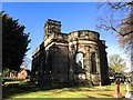
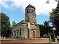
Alsager: Christ Church
View from the east end: for the west end see Image The church's history and architecture are summarised in http://en.wikipedia.org/wiki/Christ_Church,_Alsager while the current website is http://www.christchurch-alsager.org.uk/.
Image: © Jonathan Hutchins
Taken: 3 Nov 2014
0.17 miles