IMAGES TAKEN NEAR TO
Farrell Drive, STOKE-ON-TRENT, ST7 2GY
Introduction
This page details the photographs taken nearby to Farrell Drive, ST7 2GY by members of the Geograph project.
The Geograph project started in 2005 with the aim of publishing, organising and preserving representative images for every square kilometre of Great Britain, Ireland and the Isle of Man.

There are currently over 7.5m images from over14,400 individuals and you can help contribute to the project by visiting https://www.geograph.org.uk
Image Map
Images are licensed for reuse under creativecommons.org/licenses/by-sa/2.0
Notes
- Clicking on the map will re-center to the selected point.
- The higher the marker number, the further away the image location is from the centre of the postcode.
Image Listing (6 Images Found)
Images are licensed for reuse under creativecommons.org/licenses/by-sa/2.0
Image
Details
Distance
5
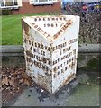
Old Milepost by the B5077 in Cranberry Moss
Cast iron post by the B5077, in parish of Alsager (Congleton District), Crewe Road, Cranberry Moss, West of Alsager, in pavement in front of lawn of No. 253, on North side of road. Cast iron CCC1901, erected by the County Council in the 20th century.
Inscription reads:-
: KIDSGROVE / 4 MILES / TUNSTALL 6½ / BURSLEM 8 : : CHESHIRE / 1901 / COUNTY COUNCIL : : RADWAY GREEN / ½ MILE / BARTHOMLEY 1¾ / WESTON 4½ / CREWE 6¼ :
Maker:-
: W H SMITH & CO / MAKERS / WHITCHURCH :
Milestone Society National ID: CH_KGCW04
Image: © J Higgins
Taken: 1 Aug 2003
0.19 miles
6
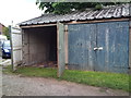
Lock-up garages off Coronation Avenue, Alsager
Image: © Jonathan Hutchins
Taken: 24 Jul 2011
0.24 miles