IMAGES TAKEN NEAR TO
Duncan Road, STOKE-ON-TRENT, ST7 2FG
Introduction
This page details the photographs taken nearby to Duncan Road, ST7 2FG by members of the Geograph project.
The Geograph project started in 2005 with the aim of publishing, organising and preserving representative images for every square kilometre of Great Britain, Ireland and the Isle of Man.

There are currently over 7.5m images from over14,400 individuals and you can help contribute to the project by visiting https://www.geograph.org.uk
Image Map
Images are licensed for reuse under creativecommons.org/licenses/by-sa/2.0
Notes
- Clicking on the map will re-center to the selected point.
- The higher the marker number, the further away the image location is from the centre of the postcode.
Image Listing (5 Images Found)
Images are licensed for reuse under creativecommons.org/licenses/by-sa/2.0
Image
Details
Distance
1
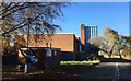
Disused university campus at Alsager
Manchester Metropolitan University (MMU) has closed this site, and staff have been moved to the Crewe campus. The site is proposed for residential and other development.
Image: © Jonathan Hutchins
Taken: 3 Nov 2014
0.03 miles
2
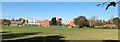
Disused university campus at Alsager
Manchester Metropolitan University (MMU) has proposed this site for redevelopment
Image: © Jonathan Hutchins
Taken: 3 Nov 2014
0.11 miles
3
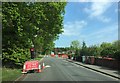
Alsager: temporary lights on Hassall Road
Image: © Jonathan Hutchins
Taken: 15 May 2015
0.16 miles
4
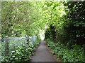
Alsager: public footpath between Lodge Road and Hassall Road
Image: © Jonathan Hutchins
Taken: 26 May 2016
0.21 miles
5
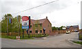
Alsager: new housing development on Hassall Road
The development is called 'Limeacre'. On this Bank Holiday Monday the show home was open and was attracting several interested parties.
Image: © Jonathan Hutchins
Taken: 25 May 2015
0.25 miles