IMAGES TAKEN NEAR TO
McGregor Close, STOKE-ON-TRENT, ST7 2FF
Introduction
This page details the photographs taken nearby to McGregor Close, ST7 2FF by members of the Geograph project.
The Geograph project started in 2005 with the aim of publishing, organising and preserving representative images for every square kilometre of Great Britain, Ireland and the Isle of Man.

There are currently over 7.5m images from over14,400 individuals and you can help contribute to the project by visiting https://www.geograph.org.uk
Image Map
Images are licensed for reuse under creativecommons.org/licenses/by-sa/2.0
Notes
- Clicking on the map will re-center to the selected point.
- The higher the marker number, the further away the image location is from the centre of the postcode.
Image Listing (16 Images Found)
Images are licensed for reuse under creativecommons.org/licenses/by-sa/2.0
Image
Details
Distance
1
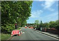
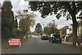
Alsager: temporary lights on Hassall Road
Image: © Jonathan Hutchins
Taken: 15 May 2015
0.05 miles
2

Disused university campus at Alsager
Manchester Metropolitan University (MMU) has closed this site, and staff have been moved to the Crewe campus. The site is proposed for residential and other development.
Image: © Jonathan Hutchins
Taken: 3 Nov 2014
0.08 miles
3
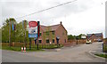
Alsager: new housing development on Hassall Road
The development is called 'Limeacre'. On this Bank Holiday Monday the show home was open and was attracting several interested parties.
Image: © Jonathan Hutchins
Taken: 25 May 2015
0.13 miles
4
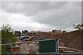
Alsager: housing construction off Hassall Road
Image: © Jonathan Hutchins
Taken: 25 May 2015
0.14 miles
5
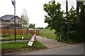
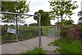
Alsager: footpath off Hassall Road
The path is re-routed past the perimeter fence of the new housing development: see http://www.geograph.org.uk/photo/4493688.
Image: © Jonathan Hutchins
Taken: 25 May 2015
0.15 miles
6

Alsager: re-routed footpath off Hassall Road
This path has been re-routed round the border of a new housing development.
Image: © Jonathan Hutchins
Taken: 25 May 2015
0.17 miles
7
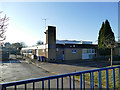
Pikemere School, Lawton Heath
A primary academy.
Image: © Stephen Craven
Taken: 30 Dec 2019
0.17 miles
8
Alsager: roadworks on Pikemere Road
Image: © Jonathan Hutchins
Taken: 22 Oct 2016
0.19 miles
9
Alsager: path and metal kissing gate
Here the path in http://www.geograph.org.uk/photo/4493688 enters fields. A look back along the newly laid path yields a view of the houses under construction http://www.geograph.org.uk/photo/4493696.
Image: © Jonathan Hutchins
Taken: 25 May 2015
0.19 miles
10

Crofton housing development, Lawton Heath (1)
These houses are on a new road called Oakley Drive, an extension of the estate seen in Image four years earlier.
Image: © Stephen Craven
Taken: 30 Dec 2019
0.21 miles