IMAGES TAKEN NEAR TO
Cody Place, ST7 2EX
Introduction
This page details the photographs taken nearby to Cody Place, ST7 2EX by members of the Geograph project.
The Geograph project started in 2005 with the aim of publishing, organising and preserving representative images for every square kilometre of Great Britain, Ireland and the Isle of Man.

There are currently over 7.5m images from over14,400 individuals and you can help contribute to the project by visiting https://www.geograph.org.uk
Image Map
Images are licensed for reuse under creativecommons.org/licenses/by-sa/2.0
Notes
- Clicking on the map will re-center to the selected point.
- The higher the marker number, the further away the image location is from the centre of the postcode.
Image Listing (3 Images Found)
Images are licensed for reuse under creativecommons.org/licenses/by-sa/2.0
Image
Details
Distance
1
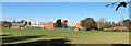
Disused university campus at Alsager
Manchester Metropolitan University (MMU) has proposed this site for redevelopment
Image: © Jonathan Hutchins
Taken: 3 Nov 2014
0.10 miles
2
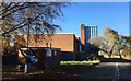
Disused university campus at Alsager
Manchester Metropolitan University (MMU) has closed this site, and staff have been moved to the Crewe campus. The site is proposed for residential and other development.
Image: © Jonathan Hutchins
Taken: 3 Nov 2014
0.13 miles
3
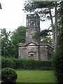
Christ Church Alsager
The first of two Anglian church buildings in the small town of Alsager.
Built and endowed in the year 1789 by three sisters, Margaret, Judith and Mary Alsager, of the Manor of Alsager. It is in the Palladin style popular in the late c18th.
The mother church at that time was the church in Barthomley, now a much smaller community than Alsager, and being three miles distant, with the roads very bad between, Christ Church was built for the convenience and comfort of tenants and others who found it difficult to attend at Barthomley.
Image: © Dennis Thorley
Taken: 11 Jul 2005
0.24 miles