IMAGES TAKEN NEAR TO
Marshes Hill, STOKE-ON-TRENT, ST6 8UE
Introduction
This page details the photographs taken nearby to Marshes Hill, ST6 8UE by members of the Geograph project.
The Geograph project started in 2005 with the aim of publishing, organising and preserving representative images for every square kilometre of Great Britain, Ireland and the Isle of Man.

There are currently over 7.5m images from over14,400 individuals and you can help contribute to the project by visiting https://www.geograph.org.uk
Image Map
Images are licensed for reuse under creativecommons.org/licenses/by-sa/2.0
Notes
- Clicking on the map will re-center to the selected point.
- The higher the marker number, the further away the image location is from the centre of the postcode.
Image Listing (2 Images Found)
Images are licensed for reuse under creativecommons.org/licenses/by-sa/2.0
Image
Details
Distance
1
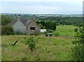
Ladymoor Gate
Shown on the OS map as a riding school but the signs seem to have disappeared.
Image: © Neil Lewin
Taken: 25 Aug 2006
0.05 miles
2
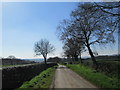
Countryside north of Brown Edge
An area of narrow lanes between Brown Edge and Biddulph.
Image: © David Weston
Taken: 8 Apr 2017
0.16 miles