IMAGES TAKEN NEAR TO
Hill Top, STOKE-ON-TRENT, ST6 8TX
Introduction
This page details the photographs taken nearby to Hill Top, ST6 8TX by members of the Geograph project.
The Geograph project started in 2005 with the aim of publishing, organising and preserving representative images for every square kilometre of Great Britain, Ireland and the Isle of Man.

There are currently over 7.5m images from over14,400 individuals and you can help contribute to the project by visiting https://www.geograph.org.uk
Image Map
Images are licensed for reuse under creativecommons.org/licenses/by-sa/2.0
Notes
- Clicking on the map will re-center to the selected point.
- The higher the marker number, the further away the image location is from the centre of the postcode.
Image Listing (4 Images Found)
Images are licensed for reuse under creativecommons.org/licenses/by-sa/2.0
Image
Details
Distance
1
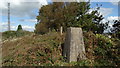
Trig point at Brown Edge, Staffs
This trig point lies just off the path but in a thicket.
Image: © Colin Park
Taken: 6 Oct 2016
0.10 miles
2
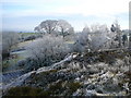
A winter's day on Marshes Hill near Brown Edge.
Image: © Colin Park
Taken: 30 Nov 2008
0.20 miles
3
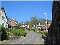
New Lane, Brown Edge
A school is in shadow on the right. A telecommunications tower is ahead.
Image: © David Weston
Taken: 8 Apr 2017
0.23 miles
4
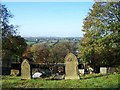
View From Churchyard, St. Anne, Brown Edge
Image: © Geoff Pick
Taken: 31 Oct 2008
0.24 miles