IMAGES TAKEN NEAR TO
Rushton Close, STOKE-ON-TRENT, ST6 8RH
Introduction
This page details the photographs taken nearby to Rushton Close, ST6 8RH by members of the Geograph project.
The Geograph project started in 2005 with the aim of publishing, organising and preserving representative images for every square kilometre of Great Britain, Ireland and the Isle of Man.

There are currently over 7.5m images from over14,400 individuals and you can help contribute to the project by visiting https://www.geograph.org.uk
Image Map
Images are licensed for reuse under creativecommons.org/licenses/by-sa/2.0
Notes
- Clicking on the map will re-center to the selected point.
- The higher the marker number, the further away the image location is from the centre of the postcode.
Image Listing (13 Images Found)
Images are licensed for reuse under creativecommons.org/licenses/by-sa/2.0
Image
Details
Distance
1

Scooby and Shaggy
by Jake and Jamie aged 2 & 8 yrs old. (it says so on the sign)
Image: © Neil Lewin
Taken: 19 Jul 2007
0.09 miles
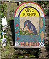
2
All creatures great and small
One of three well-dressings in Brown Edge.
Image: © Neil Lewin
Taken: 19 Jul 2007
0.09 miles
3
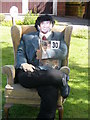
Alan Partridge - Aha
A scarecrow... I hope.
Image: © Neil Lewin
Taken: 19 Jul 2007
0.12 miles
4
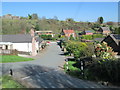
Sandy Lane, Brown Edge
At the junction of Sandy Lane (ahead), St Anne's Vale (left of photo) and Back Lane (right).
Image: © David Weston
Taken: 8 Apr 2017
0.13 miles
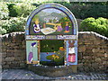
5
Wildlife Well dressing 2007
Designed and constructed by the pupils of St Annes School, Brown Edge.
Image: © Neil Lewin
Taken: 19 Jul 2007
0.13 miles
6
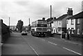
High Lane, Brown Edge ? 1970
Turner's were a small family bus company based in the village, typical of several small operators in the Potteries area serving what had been industrial communities. Both Smallthorne and Norton were essentially colliery villages.
Unlike many such operators which purchased second hand vehicles, the majority of Turner's fleet were purchased new, and were kept in very smart condition. Bus no.7 is a Daimler Fleetline with Northern Counties bodywork which entered service just a couple of months before this picture was taken.
This is one of a series of views featuring buses in the 60s, 70s, and 80s. http://www.geograph.org.uk/search.php?i=137652761
Image: © Alan Murray-Rust
Taken: 31 Aug 1970
0.14 miles
7
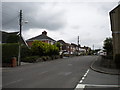
South end of Sytch Road, Brown Edge
Sytch Road heads north from High Lane towards the church and schools at the northern end of Brown Edge.
Image: © Richard Vince
Taken: 29 Jun 2013
0.14 miles
8
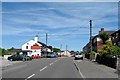
High Lane, Brown Edge (2)
Looking towards the centre of the village from the end of Willfield Avenue (right foreground).
Image: © Richard Vince
Taken: 29 Jun 2013
0.14 miles
10
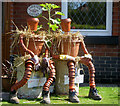
Bill and Ben
Who took part in the Brown Edge Well Dressings
Image: © Neil Lewin
Taken: 19 Jul 2007
0.16 miles