IMAGES TAKEN NEAR TO
Spring View, STOKE-ON-TRENT, ST6 8PZ
Introduction
This page details the photographs taken nearby to Spring View, ST6 8PZ by members of the Geograph project.
The Geograph project started in 2005 with the aim of publishing, organising and preserving representative images for every square kilometre of Great Britain, Ireland and the Isle of Man.

There are currently over 7.5m images from over14,400 individuals and you can help contribute to the project by visiting https://www.geograph.org.uk
Image Map
Images are licensed for reuse under creativecommons.org/licenses/by-sa/2.0
Notes
- Clicking on the map will re-center to the selected point.
- The higher the marker number, the further away the image location is from the centre of the postcode.
Image Listing (4 Images Found)
Images are licensed for reuse under creativecommons.org/licenses/by-sa/2.0
Image
Details
Distance
1
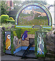
All things bright and beautiful
2007 Well dressing in Brown Edge
Image: © Neil Lewin
Taken: 19 Jul 2007
0.11 miles
2
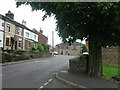
Brown Edge
Brown Edge village is part of the Staffordshire Moorlands on its border with Stoke on Trent. Formerly a mining village it is now expanded into one of the commuter villages for N. Staffordshire.
Image: © Phil Eptlett
Taken: 28 Jun 2006
0.21 miles
3
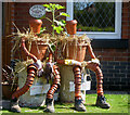
Bill and Ben
Who took part in the Brown Edge Well Dressings
Image: © Neil Lewin
Taken: 19 Jul 2007
0.22 miles
4
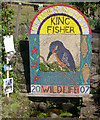
Wildlife Well dressing 2007
Designed and constructed by the pupils of St Annes School, Brown Edge.
Image: © Neil Lewin
Taken: 19 Jul 2007
0.25 miles