IMAGES TAKEN NEAR TO
Thursfield Walk, STOKE-ON-TRENT, ST6 8HE
Introduction
This page details the photographs taken nearby to Thursfield Walk, ST6 8HE by members of the Geograph project.
The Geograph project started in 2005 with the aim of publishing, organising and preserving representative images for every square kilometre of Great Britain, Ireland and the Isle of Man.

There are currently over 7.5m images from over14,400 individuals and you can help contribute to the project by visiting https://www.geograph.org.uk
Image Map
Images are licensed for reuse under creativecommons.org/licenses/by-sa/2.0
Notes
- Clicking on the map will re-center to the selected point.
- The higher the marker number, the further away the image location is from the centre of the postcode.
Image Listing (2 Images Found)
Images are licensed for reuse under creativecommons.org/licenses/by-sa/2.0
Image
Details
Distance
1
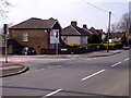
Apsley House Branch Surgery, Norton
Looking across Knypersley Road. The surgery is the building centre left on the junction with St. Nicholas Avenue, Norton in the Moors, Stoke on Trent. ST6 8JA
Image: © Carl Farnell
Taken: 21 Mar 2006
0.19 miles
2
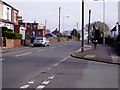
Knypersley Road, Norton
Looking across Knypersley Road from the corner of St. Nicholas Avenue, Norton in the Moors, Stoke on Trent. The flat roofed building in the middle distance/centre left is Norton Working Men's Club. ST6 8HZ
Image: © Carl Farnell
Taken: 21 Mar 2006
0.21 miles