IMAGES TAKEN NEAR TO
Chell Heath Road, STOKE-ON-TRENT, ST6 7NN
Introduction
This page details the photographs taken nearby to Chell Heath Road, ST6 7NN by members of the Geograph project.
The Geograph project started in 2005 with the aim of publishing, organising and preserving representative images for every square kilometre of Great Britain, Ireland and the Isle of Man.

There are currently over 7.5m images from over14,400 individuals and you can help contribute to the project by visiting https://www.geograph.org.uk
Image Map
Images are licensed for reuse under creativecommons.org/licenses/by-sa/2.0
Notes
- Clicking on the map will re-center to the selected point.
- The higher the marker number, the further away the image location is from the centre of the postcode.
Image Listing (11 Images Found)
Images are licensed for reuse under creativecommons.org/licenses/by-sa/2.0
Image
Details
Distance
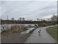
2
Footpath beside lake at Ford Green
This is a former railway line which served Chatterley Whitfield colliery.
Image: © Jonathan Hutchins
Taken: 28 Dec 2015
0.15 miles

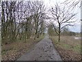
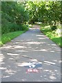
4

Tarmac route past playing field near Bradeley
The path is used by National Cycle Network route no.55.
Image: © Jonathan Hutchins
Taken: 29 Dec 2024
0.18 miles
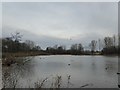
5
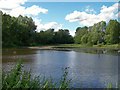
Ford Green Nature Reserve, Smallthorne
Looking across the lake. The Ford Green Brook runs across the reserve and heads south east to join with the River Trent at Milton. The area was transformed into the reserve in the 1980's and is adjacent to Ford Green Hall. Image
Image: © Carl Farnell
Taken: 26 Jun 2011
0.18 miles
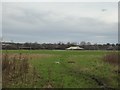
6
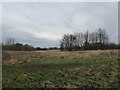
Rough grassland at Whitfield Valley LNR
On the distant horizon can be seen the spoil heap of the former Chatterley Whitfield colliery.
Image: © Jonathan Hutchins
Taken: 28 Dec 2015
0.19 miles
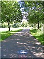
7
National Route 55, Smallthorne
Part of the National Cycle Network. When complete will connect Ironbridge to Preston via here! Looking in the direction of Bradeley (and Preston eventually).
Image: © Carl Farnell
Taken: 26 Jun 2011
0.20 miles
9
National Route 55, Smallthorne
Part of the National Cycle Network. When complete will connect Ironbridge to Preston via here! Looking in the direction of Sneyd Green (and Ironbridge eventually).
Image: © Carl Farnell
Taken: 26 Jun 2011
0.24 miles