IMAGES TAKEN NEAR TO
Houldsworth Drive, STOKE-ON-TRENT, ST6 6TG
Introduction
This page details the photographs taken nearby to Houldsworth Drive, ST6 6TG by members of the Geograph project.
The Geograph project started in 2005 with the aim of publishing, organising and preserving representative images for every square kilometre of Great Britain, Ireland and the Isle of Man.

There are currently over 7.5m images from over14,400 individuals and you can help contribute to the project by visiting https://www.geograph.org.uk
Image Map
Images are licensed for reuse under creativecommons.org/licenses/by-sa/2.0
Notes
- Clicking on the map will re-center to the selected point.
- The higher the marker number, the further away the image location is from the centre of the postcode.
Image Listing (4 Images Found)
Images are licensed for reuse under creativecommons.org/licenses/by-sa/2.0
Image
Details
Distance
1
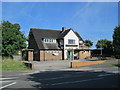
The Jester, Fegg Hayes
A pub on the edge of the Potteries, on the main road between Tunstall and Biddulph.
Image: © David Weston
Taken: 16 Aug 2016
0.12 miles
2

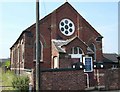
Whitfield Valley Primary School, Fegg Hayes
Image: © Steve Lewin
Taken: 4 Jul 2006
0.17 miles
4

Memories of Chatterley Whitfield
The location etc. is a best guess as these don't appear on the aerial as yet. These three coal waggons are a memory of better days although on closer examination at least two lack proper running gear. The little trees will also do their best to obscure this view.
Image: © Chris Allen
Taken: 9 Feb 2013
0.24 miles