IMAGES TAKEN NEAR TO
Granstone Close, STOKE-ON-TRENT, ST6 6SX
Introduction
This page details the photographs taken nearby to Granstone Close, ST6 6SX by members of the Geograph project.
The Geograph project started in 2005 with the aim of publishing, organising and preserving representative images for every square kilometre of Great Britain, Ireland and the Isle of Man.

There are currently over 7.5m images from over14,400 individuals and you can help contribute to the project by visiting https://www.geograph.org.uk
Image Map
Images are licensed for reuse under creativecommons.org/licenses/by-sa/2.0
Notes
- Clicking on the map will re-center to the selected point.
- The higher the marker number, the further away the image location is from the centre of the postcode.
Image Listing (5 Images Found)
Images are licensed for reuse under creativecommons.org/licenses/by-sa/2.0
Image
Details
Distance
1
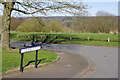
Petersfield Road, Chell
Showing the junction with Lowhurst Drive on the edge of a housing estate off Biddulph Road. The open land ahead has been designated Turnhurst Jubilee Wood.
Image: © Stephen McKay
Taken: 24 Mar 2017
0.06 miles
2
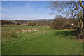
Turnhurst Jubilee Wood
This area of land between Lowhurst Drive and Biddulph Road has been designated Turnhurst Jubilee Wood and is gradually being turned into woodland. Part of this scene was once occupied by Chell Colliery.
Image: © Stephen McKay
Taken: 24 Mar 2017
0.12 miles
3
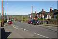
Biddulph Road, Chell
Looking along the A527 towards Biddulph.
Image: © Stephen McKay
Taken: 24 Mar 2017
0.17 miles
4
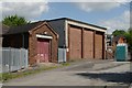
Westcliffe Hospital (Stoke) old fire station
Westcliffe Hospital (Stoke) old fire station, at the now closed Westcliffe Hospital, Turnhurst Road, Stoke On Trent, Staffordshire
Image: © Kevin Hale
Taken: 27 May 2010
0.22 miles
5
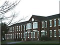
Westcliffe Hospital
Built in 1894 by the Wolstanton and Burslem Union as an addition to the existing workhouse.
Image: © Steve Lewin
Taken: 27 Dec 2005
0.23 miles