IMAGES TAKEN NEAR TO
Rivington Crescent, STOKE-ON-TRENT, ST6 6RD
Introduction
This page details the photographs taken nearby to Rivington Crescent, ST6 6RD by members of the Geograph project.
The Geograph project started in 2005 with the aim of publishing, organising and preserving representative images for every square kilometre of Great Britain, Ireland and the Isle of Man.

There are currently over 7.5m images from over14,400 individuals and you can help contribute to the project by visiting https://www.geograph.org.uk
Image Map
Images are licensed for reuse under creativecommons.org/licenses/by-sa/2.0
Notes
- Clicking on the map will re-center to the selected point.
- The higher the marker number, the further away the image location is from the centre of the postcode.
Image Listing (6 Images Found)
Images are licensed for reuse under creativecommons.org/licenses/by-sa/2.0
Image
Details
Distance
1
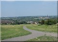
Monks-Neil Park, Chell Heath
View across the park, looking towards Fegg Hayes and on to Chatterly Whitfield
Image: © Steve Lewin
Taken: 4 Jul 2006
0.12 miles
3
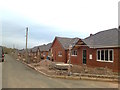
New houses, Warren Road, Monks-Neil Park
Image: © Alex McGregor
Taken: 6 Jan 2012
0.18 miles
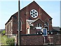
4
Whitfield Valley Primary School, Fegg Hayes
Image: © Steve Lewin
Taken: 4 Jul 2006
0.19 miles
5
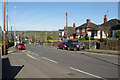
Biddulph Road, Chell
Looking along the A527 towards Biddulph.
Image: © Stephen McKay
Taken: 24 Mar 2017
0.22 miles
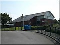
6
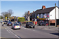
Biddulph Road, Chell
Part of the A527 towards Biddulph. On the right is Mickey's Convenience Store and Chell Post Office.
Image: © Stephen McKay
Taken: 24 Mar 2017
0.23 miles