IMAGES TAKEN NEAR TO
Baskeyfield Place, STOKE-ON-TRENT, ST6 6HU
Introduction
This page details the photographs taken nearby to Baskeyfield Place, ST6 6HU by members of the Geograph project.
The Geograph project started in 2005 with the aim of publishing, organising and preserving representative images for every square kilometre of Great Britain, Ireland and the Isle of Man.

There are currently over 7.5m images from over14,400 individuals and you can help contribute to the project by visiting https://www.geograph.org.uk
Image Map
Images are licensed for reuse under creativecommons.org/licenses/by-sa/2.0
Notes
- Clicking on the map will re-center to the selected point.
- The higher the marker number, the further away the image location is from the centre of the postcode.
Image Listing (6 Images Found)
Images are licensed for reuse under creativecommons.org/licenses/by-sa/2.0
Image
Details
Distance
1
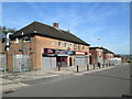
Shops at Chell Heath
On a road alongside Chell Heath Road. The small building to the right of the shops is an electricity substation.
Image: © David Weston
Taken: 16 Aug 2016
0.05 miles
2
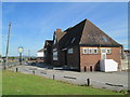
The Knave of Clubs, Chell Heath
A pub on Chell Heath Road, near a roundabout.
Image: © David Weston
Taken: 16 Aug 2016
0.11 miles
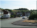
3
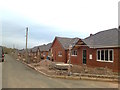
New houses, Warren Road, Monks-Neil Park
Image: © Alex McGregor
Taken: 6 Jan 2012
0.13 miles
5
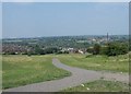
Monks-Neil Park, Chell Heath
View across the park, looking towards Fegg Hayes and on to Chatterly Whitfield
Image: © Steve Lewin
Taken: 4 Jul 2006
0.21 miles
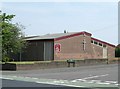
6
Barncroft Road, Chell Heath
A residential area north of Burslem. Looking towards Catharine Road at the end of Barncroft Road; on the right is Meadow Road.
Image: © David Weston
Taken: 16 Aug 2016
0.22 miles