IMAGES TAKEN NEAR TO
Melstone Avenue, STOKE-ON-TRENT, ST6 6EX
Introduction
This page details the photographs taken nearby to Melstone Avenue, ST6 6EX by members of the Geograph project.
The Geograph project started in 2005 with the aim of publishing, organising and preserving representative images for every square kilometre of Great Britain, Ireland and the Isle of Man.

There are currently over 7.5m images from over14,400 individuals and you can help contribute to the project by visiting https://www.geograph.org.uk
Image Map
Images are licensed for reuse under creativecommons.org/licenses/by-sa/2.0
Notes
- Clicking on the map will re-center to the selected point.
- The higher the marker number, the further away the image location is from the centre of the postcode.
Image Listing (8 Images Found)
Images are licensed for reuse under creativecommons.org/licenses/by-sa/2.0
Image
Details
Distance
1
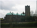
Tunstall Catholic Church
Sacred Heart Church, Tunstall, Stoke on Trent. Opened in June 1930, its huge copper domes can be seen for miles around
Image: © Phil Eptlett
Taken: 7 Apr 2006
0.15 miles
2
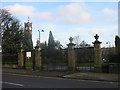
Tunstall Park Gates
These gates at Tunstall park in Stoke on Trent were donated by the children of Thomas Peake in 1904, who was a well known local pottery owner.
Image: © Phil Eptlett
Taken: 12 Jan 2006
0.19 miles
3

Tunstall Primary Care Centre
This is accommodated in the Alexandra Park retail development, a project of Dransfield Properties http://www.dransfield.co.uk/property.php?id=74. It opened in September 2011.
Image: © Jonathan Hutchins
Taken: 30 Dec 2014
0.21 miles
4
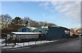
Tunstall: Morris Brothers, Scotia Road
Morris Brothers was formed in 1948 by two brothers, Fred and Harry Morris. It began by offering specialised engineering services to the local pottery industry, but early on became involved with the precast concrete industry, and now works largely in this area. It is still a family firm. http://www.morrisbrothers.com/about-us.php
Image: © Jonathan Hutchins
Taken: 30 Dec 2014
0.22 miles
5
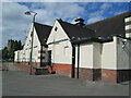
Community centre, Tunstall
A community centre next to Victoria Park, Tunstall.
Image: © David Weston
Taken: 20 Aug 2023
0.22 miles
6
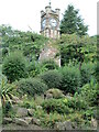
Clock tower in Victoria Park, Tunstall
The clock tower was erected in 1907, in memory of William Adams (1833-1905), owner of a pottery factory. It stands at the south-west corner of an artificial terrace known as The Battlements; this view is from below the terrace.
Image: © David Weston
Taken: 20 Aug 2023
0.22 miles
7
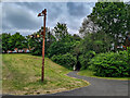
Railway Signal, Potteries Loop Line (Dismantled)
Opened 1873
Closed 1964
Now Cycle route 5 / Footpath
https://en.wikipedia.org/wiki/Potteries_Loop_Line
Image: © Brian Deegan
Taken: 20 Jun 2021
0.24 miles
8
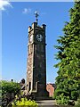
The Adams Clock Tower, Tunstall Park, Stoke-on-Trent
Image: © Andrew Woodvine
Taken: 20 Jun 2022
0.25 miles