IMAGES TAKEN NEAR TO
Clanway Street, STOKE-ON-TRENT, ST6 5UJ
Introduction
This page details the photographs taken nearby to Clanway Street, ST6 5UJ by members of the Geograph project.
The Geograph project started in 2005 with the aim of publishing, organising and preserving representative images for every square kilometre of Great Britain, Ireland and the Isle of Man.

There are currently over 7.5m images from over14,400 individuals and you can help contribute to the project by visiting https://www.geograph.org.uk
Image Map
Images are licensed for reuse under creativecommons.org/licenses/by-sa/2.0
Notes
- Clicking on the map will re-center to the selected point.
- The higher the marker number, the further away the image location is from the centre of the postcode.
Image Listing (8 Images Found)
Images are licensed for reuse under creativecommons.org/licenses/by-sa/2.0
Image
Details
Distance
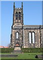
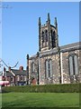
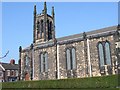
3
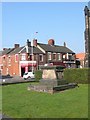
Churchyard at Christ Church Tunstall
Image: © Clive Woolliscroft
Taken: 26 Mar 2007
0.22 miles
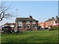
8
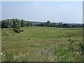
Clanway Sports Stadium (long gone)
This amphitheatre and the rough outline of the old track are all that is left of the sports stadium (still marked on the 2006 OS map). Soon this area will be part of Tunstall Northern Bypass and a new estate of around 400 houses.
Image: © Steve Lewin
Taken: 4 Jul 2006
0.24 miles