IMAGES TAKEN NEAR TO
High Street, STOKE-ON-TRENT, ST6 5TT
Introduction
This page details the photographs taken nearby to High Street, ST6 5TT by members of the Geograph project.
The Geograph project started in 2005 with the aim of publishing, organising and preserving representative images for every square kilometre of Great Britain, Ireland and the Isle of Man.

There are currently over 7.5m images from over14,400 individuals and you can help contribute to the project by visiting https://www.geograph.org.uk
Image Map
Images are licensed for reuse under creativecommons.org/licenses/by-sa/2.0
Notes
- Clicking on the map will re-center to the selected point.
- The higher the marker number, the further away the image location is from the centre of the postcode.
Image Listing (56 Images Found)
Images are licensed for reuse under creativecommons.org/licenses/by-sa/2.0
Image
Details
Distance
1
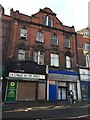
Tunstall: closed shops on High Street
Some would ascribe the decline in traditional 'High Street' shops to the rise of less central retail parks - such as, in the case of Tunstall, Jasper Square and Alexandra Park.
Image: © Jonathan Hutchins
Taken: 30 Dec 2014
0.04 miles
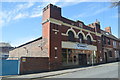
2
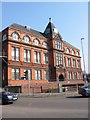
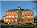
Queen Victoria Jubilee Buildings
Image: © Clive Woolliscroft
Taken: 26 Mar 2007
0.04 miles
4
Emperor Takeaway on Scotia Road, Stoke on Trent
Image: © Ian S
Taken: 5 Jan 2022
0.05 miles
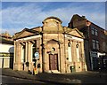
5
Tunstall Library and Baths
The Queen Victoria Jubilee Building, on the corner of the A50 and A527, dates from 1889 and is still in use as a public library and swimming baths. It was part of the town centre but is now separated from the main part of Tunstall by the re-routed A50.
Image: © Steve Lewin
Taken: 27 Dec 2005
0.05 miles
6
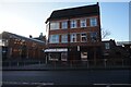
Tunstall: Former bank building on High Street
This 1920s building was formerly a branch of HSBC bank, which closed in September 2012. It then lay unoccupied before being refurbished to house two small businesses, Netinspire and Dunion & Co.
Image: © Jonathan Hutchins
Taken: 30 Dec 2014
0.05 miles
7
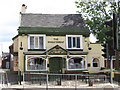
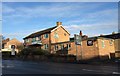
Tunstall - The Wheatsheaf
On High Street.
Image: © Dave Bevis
Taken: 7 Jul 2011
0.07 miles
8
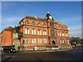
Tunstall Public Library
A Grade II listed building of 1889. At the rear are the Public Baths of the same vintage, linked to the Library via its rear courtyard range http://www.thepotteries.org/listed/165a.html.
Image: © Jonathan Hutchins
Taken: 30 Dec 2014
0.07 miles
9
Crompo's Snooker Hall - Greengates Street
Former drill hall dating from 1897 to a design by architect A R Wood.
Image: © John M
Taken: 16 Apr 2014
0.07 miles
10
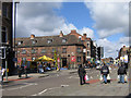
Tunstall High Street
The Sneyd Arms, in the middleground, commemorates the Sneyd family, whose seat was Keele Hall, now the site of Keele University.
Image: © Ian Capper
Taken: 5 Apr 2008
0.07 miles