IMAGES TAKEN NEAR TO
Sneyd Place, STOKE-ON-TRENT, ST6 5PU
Introduction
This page details the photographs taken nearby to Sneyd Place, ST6 5PU by members of the Geograph project.
The Geograph project started in 2005 with the aim of publishing, organising and preserving representative images for every square kilometre of Great Britain, Ireland and the Isle of Man.

There are currently over 7.5m images from over14,400 individuals and you can help contribute to the project by visiting https://www.geograph.org.uk
Image Map
Images are licensed for reuse under creativecommons.org/licenses/by-sa/2.0
Notes
- Clicking on the map will re-center to the selected point.
- The higher the marker number, the further away the image location is from the centre of the postcode.
Image Listing (8 Images Found)
Images are licensed for reuse under creativecommons.org/licenses/by-sa/2.0
Image
Details
Distance
3
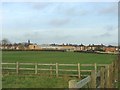
Sandyford from Holly Wall Farm
The view across the fields from the farm to Holly Wall Primary School and the Sandyford estate.
Image: © Steve Lewin
Taken: 12 Jan 2006
0.10 miles
6
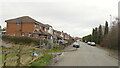
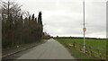
The main road north of Tunstall
The A50 at Sandyford, between Tunstall and Kidsgrove. On the left is the junction with Broadfield Road.
Image: © David Weston
Taken: 5 Jul 2016
0.16 miles
8
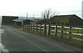
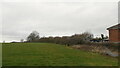
Holly Wall Farm
Holly Wall Farm is only about 200m from a housing estate and less than 600m from the main A50 in what most people would regard as a solidly built-up area.
Image: © Steve Lewin
Taken: 12 Jan 2006
0.24 miles