IMAGES TAKEN NEAR TO
Wignall Road, STOKE-ON-TRENT, ST6 5LD
Introduction
This page details the photographs taken nearby to Wignall Road, ST6 5LD by members of the Geograph project.
The Geograph project started in 2005 with the aim of publishing, organising and preserving representative images for every square kilometre of Great Britain, Ireland and the Isle of Man.

There are currently over 7.5m images from over14,400 individuals and you can help contribute to the project by visiting https://www.geograph.org.uk
Image Map
Images are licensed for reuse under creativecommons.org/licenses/by-sa/2.0
Notes
- Clicking on the map will re-center to the selected point.
- The higher the marker number, the further away the image location is from the centre of the postcode.
Image Listing (5 Images Found)
Images are licensed for reuse under creativecommons.org/licenses/by-sa/2.0
Image
Details
Distance
1
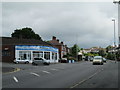
The main road north of Tunstall
The A50 at Sandyford, between Tunstall and Kidsgrove. On the left is the junction with Broadfield Road.
Image: © David Weston
Taken: 5 Jul 2016
0.07 miles
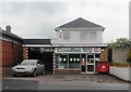
3

Sandyford cricket ground
Viewed from the end of Shelford Road.
Image: © David Weston
Taken: 5 Jul 2016
0.14 miles
4
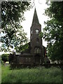
St John's Church, Goldenhill
Church of St John the Evangelist, seen from the churchyard. It was built in 1841, and was closed in 2014.
Image: © David Weston
Taken: 5 Jul 2016
0.25 miles
5
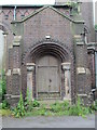
Door of St John's Church, Goldenhill
Door on the north side of the Church of St John the Evangelist. The church was built in 1841 in Romanesque style. It has been closed since 2014.
Image: © David Weston
Taken: 5 Jul 2016
0.25 miles