IMAGES TAKEN NEAR TO
Gill Bank, STOKE-ON-TRENT, ST6 4QW
Introduction
This page details the photographs taken nearby to Gill Bank, ST6 4QW by members of the Geograph project.
The Geograph project started in 2005 with the aim of publishing, organising and preserving representative images for every square kilometre of Great Britain, Ireland and the Isle of Man.

There are currently over 7.5m images from over14,400 individuals and you can help contribute to the project by visiting https://www.geograph.org.uk
Image Map
Images are licensed for reuse under creativecommons.org/licenses/by-sa/2.0
Notes
- Clicking on the map will re-center to the selected point.
- The higher the marker number, the further away the image location is from the centre of the postcode.
Image Listing (5 Images Found)
Images are licensed for reuse under creativecommons.org/licenses/by-sa/2.0
Image
Details
Distance
1
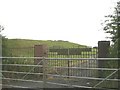
Entrance to covered reservoir
This reservoir, to the south east of Gill Bank Road was once run by the Staffordshire Potteries Water Board as the original gate shows.
Image: © Steve Lewin
Taken: 6 Jul 2006
0.08 miles
3
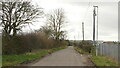
Gill Bank Road
Passing between covered reservoirs.
Image: © Richard Webb
Taken: 17 Mar 2022
0.13 miles
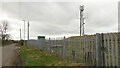
5
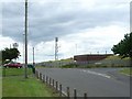
Reservoir and mobile phone masts
This covered reservoir is on the north side of Gill Bank road at the junction with Chatterley Drive. Behind it are 3 mobile phone masts and base stations grouped together in one field.
Image: © Steve Lewin
Taken: 7 Jul 2006
0.16 miles