IMAGES TAKEN NEAR TO
Broadfield, STOKE-ON-TRENT, ST6 4QG
Introduction
This page details the photographs taken nearby to Broadfield, ST6 4QG by members of the Geograph project.
The Geograph project started in 2005 with the aim of publishing, organising and preserving representative images for every square kilometre of Great Britain, Ireland and the Isle of Man.

There are currently over 7.5m images from over14,400 individuals and you can help contribute to the project by visiting https://www.geograph.org.uk
Image Map
Images are licensed for reuse under creativecommons.org/licenses/by-sa/2.0
Notes
- Clicking on the map will re-center to the selected point.
- The higher the marker number, the further away the image location is from the centre of the postcode.
Image Listing (3 Images Found)
Images are licensed for reuse under creativecommons.org/licenses/by-sa/2.0
Image
Details
Distance
2
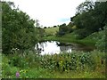
Pond below Latebrook House
The pond, between Latebrook House Farm and the council caravan park, is quite difficult to spot. Unfortunately quite a lot of rubbish has been tipped into it and it is now surrounded by banked earthworks in an attempt to stop any more tipping.
Image: © Steve Lewin
Taken: 7 Jul 2006
0.10 miles
3
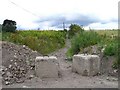
Track past Latebrook House
Just because a track is marked on the OS maps doesn't mean you can rely on it being passable. This is the white (other road, drive or track) from SJ845526 to SJ849530. Only the top part from Goldenhill to the farm is open.
Image: © Steve Lewin
Taken: 7 Jul 2006
0.10 miles