IMAGES TAKEN NEAR TO
Brownhills Road, STOKE-ON-TRENT, ST6 4LB
Introduction
This page details the photographs taken nearby to Brownhills Road, ST6 4LB by members of the Geograph project.
The Geograph project started in 2005 with the aim of publishing, organising and preserving representative images for every square kilometre of Great Britain, Ireland and the Isle of Man.

There are currently over 7.5m images from over14,400 individuals and you can help contribute to the project by visiting https://www.geograph.org.uk
Image Map
Images are licensed for reuse under creativecommons.org/licenses/by-sa/2.0
Notes
- Clicking on the map will re-center to the selected point.
- The higher the marker number, the further away the image location is from the centre of the postcode.
Image Listing (36 Images Found)
Images are licensed for reuse under creativecommons.org/licenses/by-sa/2.0
Image
Details
Distance
1
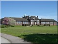
Brownhills High School
Opened in the early 1930s as the first grammar school for girls in Stoke-on-Trent the school is currently officially known as Brownhills Maths and Computing College but everyone, including students and teachers, still call it Brownhills High.
Image: © Steve Lewin
Taken: 5 May 2006
0.05 miles
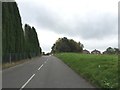
6
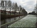
Trent and Mersey Canal: between bridges 128 and 127A
Westport Lake lies to the right below the embankment. The new housing estate on the left replaces industrial units swept away some years ago.
Image: © Jonathan Hutchins
Taken: 30 Dec 2014
0.18 miles
7
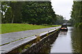
Trent & Mersey Canal beside Westport Lake
Image: © David Martin
Taken: 26 Jul 2015
0.18 miles
8
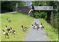
Canada geese next to Brownhills Bridge No 128
Along the Trent & Mersey Canal in Stoke-on-Trent. The geese are heading towards the nearby Westport Lake.
Image: © Mat Fascione
Taken: 11 Jul 2015
0.19 miles
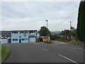
10
Longport: Botesworth Gardens/Cloughwood Way
This housing development lies parallel to the Trent and Mersey Canal on the eastern side, opposite Westport Lake.
Image: © Jonathan Hutchins
Taken: 18 Oct 2015
0.19 miles