IMAGES TAKEN NEAR TO
Navigation Road, STOKE-ON-TRENT, ST6 3RU
Introduction
This page details the photographs taken nearby to Navigation Road, ST6 3RU by members of the Geograph project.
The Geograph project started in 2005 with the aim of publishing, organising and preserving representative images for every square kilometre of Great Britain, Ireland and the Isle of Man.

There are currently over 7.5m images from over14,400 individuals and you can help contribute to the project by visiting https://www.geograph.org.uk
Image Map
Images are licensed for reuse under creativecommons.org/licenses/by-sa/2.0
Notes
- Clicking on the map will re-center to the selected point.
- The higher the marker number, the further away the image location is from the centre of the postcode.
Image Listing (33 Images Found)
Images are licensed for reuse under creativecommons.org/licenses/by-sa/2.0
Image
Details
Distance
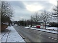
1
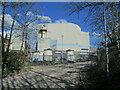
Navigation Road, Middleport
A factory near Burslem.
Image: © David Weston
Taken: 24 Apr 2022
0.10 miles
2
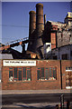
The Furlong Mills Co Ltd, Furlong lane, Burslem
Calciners and millers for the pottery industry. The two kilns are for calcination rather than the firing of pots and I believe they were in use when the picture was taken and are only relatively recently out of use.
The works is not really a pottery as it supplies material for the potteries.
Image: © Chris Allen
Taken: Unknown
0.11 miles
3
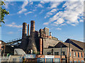
Conical Bottle Kilns, Furlong Lane, Middleport, Burslem
Image: © Brian Deegan
Taken: 3 Aug 2020
0.12 miles
6
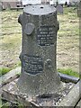
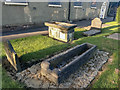
Unusual grave stone in churchyard
Unusual, tree stump shaped gravestone in Burslam
Image: © Paul Foster
Taken: 28 Apr 2023
0.15 miles
8
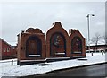
Burslem bypass triptych
This sculpture by John McKenna was commissioned by Staffordshire County Council. Glazed brick relief, 9m wide by 4.5m high, depicting the historical industrial occupations of Burslem.
Image: © Jonathan Hutchins
Taken: 17 Jan 2016
0.17 miles
9
Witch Molly Leigh Grave, Burslem
Molly Leigh died in 1746 and was buried in Burslem churchyard, but there were claims that her ghost haunted the town. Spencer—along with clerics from Stoke, Wolstanton, and Newcastle-under-Lyme—exhumed her body, opened the coffin, and threw in a still-living blackbird that had been her companion. They then reburied Molly in a north to south direction, at a right angle to all the other graves in the churchyard.
https://en.wikipedia.org/wiki/Molly_Leigh
Image: © Brian Deegan
Taken: 17 Sep 2019
0.18 miles
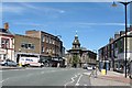
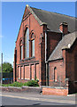
10
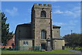
St John's Church, Burslem
The church tower dates from 1536 though the remainder was rebuilt in 1717. Josiah Wedgwood was baptised in the church in 1730 and served his apprenticeship in the adjacent Churchyard Pottery Works established by his great grandfather in 1656.
Image: © John M
Taken: 16 Apr 2014
0.18 miles