IMAGES TAKEN NEAR TO
Clovelly Walk, STOKE-ON-TRENT, ST6 3NY
Introduction
This page details the photographs taken nearby to Clovelly Walk, ST6 3NY by members of the Geograph project.
The Geograph project started in 2005 with the aim of publishing, organising and preserving representative images for every square kilometre of Great Britain, Ireland and the Isle of Man.

There are currently over 7.5m images from over14,400 individuals and you can help contribute to the project by visiting https://www.geograph.org.uk
Image Map
Images are licensed for reuse under creativecommons.org/licenses/by-sa/2.0
Notes
- Clicking on the map will re-center to the selected point.
- The higher the marker number, the further away the image location is from the centre of the postcode.
Image Listing (153 Images Found)
Images are licensed for reuse under creativecommons.org/licenses/by-sa/2.0
Image
Details
Distance
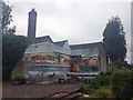
2
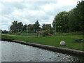
Children's playground, Middleport Park
On the east bank of the Trent & Mersey Canal, off Navigation Street.
Image: © Christine Johnstone
Taken: 25 Sep 2020
0.09 miles
3
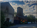
Square Calcining Bottle Kiln, Burslem
Square calcining kiln in Milvale Street, Middleport, Burslem - alongside the Trent & Mersey Canal.
Image: © Brian Deegan
Taken: 3 Aug 2020
0.09 miles
4
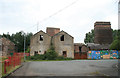
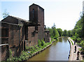
Middleport Mill
Derelict Grade II listed former calcining mills with the kilns to the right.
Image: © Chris Allen
Taken: 23 Aug 2009
0.09 miles

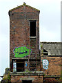
6
Middleport - factory near Milvale Street bridge
Image: © Dave Bevis
Taken: 2 May 2011
0.10 miles
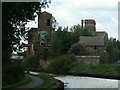
7
Middleport Mill (detail), Stoke-on-Trent
Seen from the Trent and Mersey Canal, Middleport Mill has been derelict for many years, but is a Grade II listed group of early 19th century buildings used as a calcining works.
Image: © Roger D Kidd
Taken: 3 Sep 2014
0.10 miles
8

Middleport Mill (detail), Stoke-on-Trent
Seen from the Trent and Mersey Canal, Middleport Mill has been derelict for many years, but is a Grade II listed group of early 19th century buildings used as a calcining works.
http://www.thepotteries.org/heritage/waterfront.htm
http://www.thepotteries.org/listed/102a.html
Image: © Roger D Kidd
Taken: 3 Sep 2014
0.10 miles
9
Calcining works, Milvale Street, from the south-east
Seen from a boat heading north on the Trent & Mersey Canal.
Image: © Christine Johnstone
Taken: 25 Sep 2020
0.10 miles
10

Derelict canalside flour mill near Middleport
This is by the Trent and Mersey Canal, looking south-east towards Mill Bridge, No 125. Middleport Flour Mill was also known as Port Vale Corn Mill. It was built c1844 and operated under various ownerships as a flour mill until 1924. In 1960 the lower floors were used by The Five Towns Fireplaces Ltd, but the rest of the site became derelict. (Source https://www.28dayslater.co.uk/threads/middleport-mill-calcining-works-flour-mill-stoke-on-trent-august-2019.120728/)
Mediocre quality image due to difficult lighting conditions.
Image: © Roger Kidd
Taken: 9 Sep 2014
0.10 miles