IMAGES TAKEN NEAR TO
Elder Road, STOKE-ON-TRENT, ST6 2JW
Introduction
This page details the photographs taken nearby to Elder Road, ST6 2JW by members of the Geograph project.
The Geograph project started in 2005 with the aim of publishing, organising and preserving representative images for every square kilometre of Great Britain, Ireland and the Isle of Man.

There are currently over 7.5m images from over14,400 individuals and you can help contribute to the project by visiting https://www.geograph.org.uk
Image Map
Images are licensed for reuse under creativecommons.org/licenses/by-sa/2.0
Notes
- Clicking on the map will re-center to the selected point.
- The higher the marker number, the further away the image location is from the centre of the postcode.
Image Listing (50 Images Found)
Images are licensed for reuse under creativecommons.org/licenses/by-sa/2.0
Image
Details
Distance
1
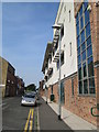
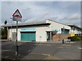
Remer Street, Cobridge
Looking along Remer Street, from the junction with Elder Road. On the right is Cobridge Community Health Centre, which is a new building; construction started in summer 2010; it opened in autumn 2011.
Image: © David Weston
Taken: 18 Jul 2013
0.01 miles
2
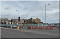
Cobridge: demolition at the crossroads
The crossroads in question is that of the A50 and A53. The former, in the foreground, heads north-west towards Burslem, Fenton and Kidsgrove. On the right in the background the A53 is bound for Endon and on to Leek and Buxton.
Image: © Jonathan Hutchins
Taken: 24 Sep 2016
0.03 miles
3
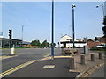
Crossroads, Cobridge
Looking along the A50 (Waterloo Road, which leads to Burslem) where it intersects with the A53 (Cobridge Road to the left, Elder Road to the right). The church tower seen to the right of centre is of Christ Church, Cobridge. On the near corner, right of centre, is a plant container which perhaps was once a horse trough.
Image: © David Weston
Taken: 18 Jul 2013
0.04 miles
5
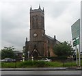
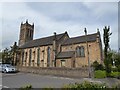
Christ Church, Cobridge
This church is Grade II listed, see https://historicengland.org.uk/listing/the-list/list-entry/1291092
Pevsner writes:
"1838-40 by L.G.Hales, a local brass-founder. New chancel 1899. Yellow brick. W tower with lancet bell-openings. Lancets and buttresses along the sides." (The Buildings of England: Staffordshire (Penguin, 1974) p.255)
Image: © Jonathan Hutchins
Taken: 17 Jan 2023
0.04 miles
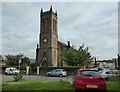
6
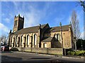
Christ Church, Cobridge
Parish church. 1839-40, enlarged 1845. By Francis Bedford. Grade II listed.
Historic England entry: https://www.historicengland.org.uk/listing/the-list/list-entry/1291092
Image: © Jonathan Hutchins
Taken: 24 Sep 2016
0.04 miles
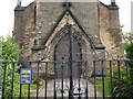
7
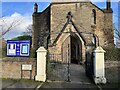
Entrance to Christ Church, Cobridge
This church is Grade II listed, see https://historicengland.org.uk/listing/the-list/list-entry/1291092
Pevsner writes:
"1838-40 by L.G.Hales, a local brass-founder. New chancel 1899. Yellow brick. W tower with lancet bell-openings. Lancets and buttresses along the sides." (The Buildings of England: Staffordshire (Penguin, 1974) p.255)
The inscriptions either side of the entrance state:
ERECTED
1839-40
ENLARGED
1845
Image: © Jonathan Hutchins
Taken: 17 Jan 2023
0.05 miles
8
Christ Church, Cobridge: west end
For the church itself see http://www.geograph.org.uk/photo/5136315
Image: © Jonathan Hutchins
Taken: 24 Sep 2016
0.05 miles
9
Christ Church, Cobridge
Parish church. 1839-40, enlarged 1845. By Francis Bedford. Grade II listed.
Historic England entry: https://www.historicengland.org.uk/listing/the-list/list-entry/1291092
Image: © Jonathan Hutchins
Taken: 24 Sep 2016
0.05 miles