IMAGES TAKEN NEAR TO
Coseley Street, STOKE-ON-TRENT, ST6 1LP
Introduction
This page details the photographs taken nearby to Coseley Street, ST6 1LP by members of the Geograph project.
The Geograph project started in 2005 with the aim of publishing, organising and preserving representative images for every square kilometre of Great Britain, Ireland and the Isle of Man.

There are currently over 7.5m images from over14,400 individuals and you can help contribute to the project by visiting https://www.geograph.org.uk
Image Map
Images are licensed for reuse under creativecommons.org/licenses/by-sa/2.0
Notes
- Clicking on the map will re-center to the selected point.
- The higher the marker number, the further away the image location is from the centre of the postcode.
Image Listing (7 Images Found)
Images are licensed for reuse under creativecommons.org/licenses/by-sa/2.0
Image
Details
Distance
1
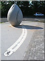
Sculpture at Ford Green
Built in the nature reserve car park, this sculpture for the community is by Denise O'Sullivan.
Image: © Neil Lewin
Taken: 19 Jul 2007
0.14 miles
2
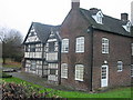
Ford Green Hall, Stoke on Trent
The hall is a 17th century house and period garden open to the public. It is furnished with original and reproduction textiles, ceramics and furniture.
Image: © Phil Eptlett
Taken: 21 Dec 2005
0.23 miles
3
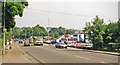
Site of Ford Green & Smallthorne station, 1999
View NE on the B5051 Burslem - Endon road. The station, which closed to passengers 11/7/27 (goods 6/1/64), had been on the right: ex-North Stafford Stoke-on-Trent - Biddulph - Congleton line: this (closed north of Biddulph 1/4/68) ran underneath the road and last bore a train in February 1989. The White Valley Nature Reserve on the Biddulph River is on the left.
Image: © Ben Brooksbank
Taken: 6 Sep 1999
0.23 miles
4
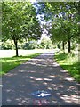
National Route 55, Smallthorne
Part of the National Cycle Network. When complete will connect Ironbridge to Preston via here! Looking in the direction of Sneyd Green (and Ironbridge eventually).
Image: © Carl Farnell
Taken: 26 Jun 2011
0.23 miles
5
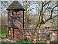
Ford Green Hall - outbuildings
This outbuilding (possibly a dovecote) is attached by a long wall to the west side of the main building. Ford Green Hall was built in 1624 for Hugh Ford. It is a fine example of a timber-framed farm house. The Ford family lived at the Hall for nearly 200 years. Mr Ford was a yeoman dairy farmer and owned 36 acres of land. In the 19th century after the Ford family left the status of the house declined and it was divided into 3 and later 4 cottages. The house contains furnishings that the Ford family might have lived with. See Image for photo of front of Hall.
Image: © Chris Beaver
Taken: 19 Mar 2015
0.24 miles
6
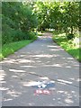
National Route 55, Smallthorne
Part of the National Cycle Network. When complete will connect Ironbridge to Preston via here! Looking in the direction of Bradeley (and Preston eventually).
Image: © Carl Farnell
Taken: 26 Jun 2011
0.24 miles
7
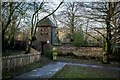
Dovecote, Ford Green Hall, Smallthorne
18th-century dovecote Grade II listed
Image: © Brian Deegan
Taken: 24 Dec 2022
0.24 miles