IMAGES TAKEN NEAR TO
Leonard Street, STOKE-ON-TRENT, ST6 1HS
Introduction
This page details the photographs taken nearby to Leonard Street, ST6 1HS by members of the Geograph project.
The Geograph project started in 2005 with the aim of publishing, organising and preserving representative images for every square kilometre of Great Britain, Ireland and the Isle of Man.

There are currently over 7.5m images from over14,400 individuals and you can help contribute to the project by visiting https://www.geograph.org.uk
Image Map
Images are licensed for reuse under creativecommons.org/licenses/by-sa/2.0
Notes
- Clicking on the map will re-center to the selected point.
- The higher the marker number, the further away the image location is from the centre of the postcode.
Image Listing (16 Images Found)
Images are licensed for reuse under creativecommons.org/licenses/by-sa/2.0
Image
Details
Distance
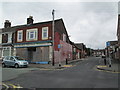
1
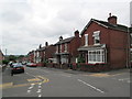
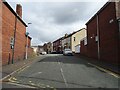
Macclesfield Street, Burslem
Looking along Macclesfield Street from the intersection with Gordon Street.
Image: © David Weston
Taken: 29 Jun 2014
0.09 miles
4
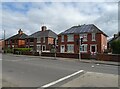
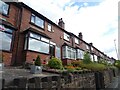
Park Inn, Burslem
Red brick pub on a corner of Dartmouth Street. It gets its name from nearby Burslem Park.
Image: © Colin Smith
Taken: 27 Jul 2010
0.12 miles
7
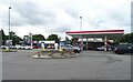
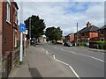
Roundabout on the A5272
Moorland Service Station behind.
Image: © JThomas
Taken: 5 Jul 2024
0.16 miles
9
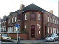
Gordon Street, Burslem
The intersection of Gordon Street and Jackfield Street (the one-way street).
Image: © David Weston
Taken: 29 Jun 2014
0.16 miles
10
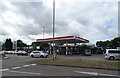
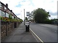
Moorland Service Station
Petrol 144.9p.
Diesel 148.9p.
Image: © JThomas
Taken: 5 Jul 2024
0.16 miles